Greenland Resource Assessment,
South-East Greenland
(Assessment Unit 6)
Executive Summary
A play-based resource assessment of conventional hydrocarbons has been performed for the onshore and offshore areas of South-East Greenland (Assessment Unit 6, AU6) which is part of the major rift complex formed during the opening of the North Atlantic. In this area, only the offshore Ammassalik Basin has been recognized and evaluated in this assessment. The remainder of the offshore areas are covered by a thick succession of basalts and has not been evaluated any further. The onshore Kangerlussuaq Basin is considered to be uplifted > 5 km and no indications of charge are present and has therefore not been evaluated any further. However, it serves as an important analogue for the offshore areas. The extent of the Ammassalik Basin is very uncertain due to the sparse seismic coverage and overlying thick succession of Palaeogene basalts but is considered to be in the order of 18,000 km2. The data quality does not lend itself to seismic stratigraphic analysis or to a break-down of the offshore sedimentary succession into individual plays as has been done for Assessment Units 1–5.
Sparce seismic data indicates the presence of a sedimentary succession with thicknesses more than 4 km in parts of the offshore area. Based on knowledge from the onshore Kangerlussuaq Basin the presence of a (Barremian?) Albian to Thanetian pre-volcanic and syn-volcanic sedimentary succession in considered to be likely in the offshore areas. The Upper Jurassic – lowermost Cretaceous Kimmeridge Clay equivalent source rock is the main source rock in the North Atlantic Rift complex. There are no indications of such a source rock in the in-board onshore Kangerlussuaq Basin, but based on the plate reconstructions it is considered possible that it could be present in the offshore basins.
Due to the scarcity of geological data and lack of mapped features in AU6, data from the analogue mature West of Shetland Basin, situated on the conjugate margin to AU6, have been used for evaluation of the resource potential. Based on these input data the mean risked recoverable volumes for AU6 is calculated to 1.7 MMBOE.
The assessment results presented are based on all available data collected and interpreted by the industry, GEUS, NUNAOIL and the Government of Greenland and reflect the state of geologic knowledge of the offshore and onshore areas of South-East Greenland at the time of study. Any future data acquisitions, drilling and evaluation of the petroleum systems and plays based on new data within this area will add to the geologic knowledge and will therefore lead to a refinement of these assessment results.
The assessment was carried out using the Player® GIS software provided by GIS-pax. The methodology and results of the assessment have been quality controlled by the Norwegian Petroleum Directorate and GIS-pax.
The results of this study are reported in an extensive ArcGIS project supported by a comprehensive presentation, reflecting the workflow of the project, including:
- Introduction
- Database
- Structural and Stratigraphic Framework
- Petroleum Systems
- Play Analysis
- Analogue Petroleum Basins
- Yet-to-Find Assessment
The Player and ArcGIS projects together with the slide pack are available for the petroleum exploration industry at no cost and can be downloaded from the project website, www.greenland-resource-assessment.gl.
Introduction
The AU6 Resource Assessment (South-East Greenland) is the sixth of seven assessments for the “Whole-of-Greenland Petroleum Resource Assessment Project” covering the entire Greenland continental shelf and the adjacent onshore areas (Fig. 1). The aim of the project is to provide an estimate of a quantitative, play-based Yet-to-Find potential of conventional hydrocarbons on the Greenland continental shelf. The project was originally initiated to help the Greenland Authorities and politicians in strategic decision making and in planning of future natural resource administration. In addition, it should identify potential needs for further geological and geophysical investigations. When oil and gas exploration was suspended in 2021, it was decided to finalize the project to have a historical document for the future, that examines the oil and gas potential in this part of the Arctic, based on all available academic and industry data.
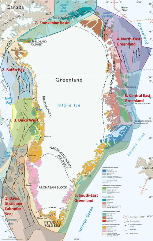
Figure 1 – Geological map of Greenland with the seven assessment units indicated.
The project is mainly sponsored by NUNAOIL and is carried out as a collaboration between GEUS, NUNAOIL and the Government of Greenland hosted by GEUS. The work is based on all available existing data provided by the industry, GEUS, NUNAOIL and the Greenland Government. The results are reported as the work on the individual assessment units are finalized.
Database
The database for AU6 includes an open offshore 2D seismic grid and gravity surveys acquired by the Danish Lithosphere Center (DLC) in the 1990s and by TGS in 2012. Ten shallow offshore boreholes have been drilled by ODP leg 163 in 1998 and 1999 of which one borehole (Site SEG80B) includes approximately 65 cm of sediments. Some scientific publications and industry reports with data are available. Excellent outcrops exist in the onshore Kangerlussuaq Basin and at Kap Gustav Holm that serve as the main analogues (Fig. 2), but also data from the West of Shetland Basin and the Irish basins located on the conjugate margin have been used as analogues.
.
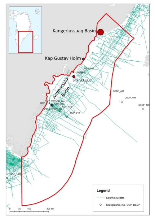
Figure 2 – Database for AU6.
Structural and Stratigraphic Framework
Due to the very low data density in the area and because only very few ‘windows’ are present in the Palaeogene basalt cover in the offshore areas, it has not been possible to perform a seismic stratigraphic analysis or divide the sedimentary succession in the offshore areas into individual plays as has been done for Assessment Units 1–5. However, excellent outcrop analogues exist in the Kangerlussuaq Basin in the northern part of the assessment area and an isolated small outcrop is also present at Kap Gustav Holm (Fig. 2). The intensely explored West of Shetland Basin on the conjugate margin also serves as an excellent analogue for evaluating the Yet-to-Find potential of the Ammassalik Basin.
Ammassalik Basin
The offshore Ammassalik Basin is the only basin in AU6 that is considered to have an exploration potential. Due to the limited seismic coverage (Fig. 2) the basin is poorly defined, however it is expected to be up to approximately 18,000 km2. It is divided into a number of sub-basins separated by basement highs (Fig. 3; Haase & Ebling 2014; Fyhn et al. 2021).
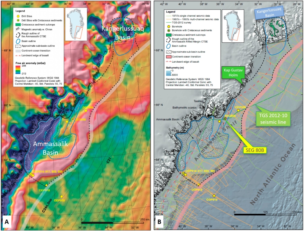
Figure 3 – A: Gravity map from Haase & Ebbing (2014). B: Map showing outline of the Ammassalik Basin and the continent–ocean boundary (from Fyhn et al. 2021).
The basin is situated along the rifted volcanic margin and is comparable with other rift basins along the North-East Atlantic margin. The continent–ocean boundary (COB) along South-East Greenland is located close to the coastline (except in the Ammassalik Shelf area) and the continental shelf is very narrow (Fig. 3; Gerlings et al. 2017; Fyhn et al. 2021).
Seismic data suggest that the sediment thickness is more than c. 4 km (Gerlings et al. 2017; Fyhn et al. 2021) and unpublished gravity modelling suggests a sedimentary succession of no more than 7–10 km.
No deep wells have been drilled in the basin and knowledge on stratigraphy, structural style and basin evolution is therefore limited. However, a 65 cm core from site SEG80B (Figs 3, 4) recovered poorly lithified sandstone with scattered organic fragments. The dinoflagellate cyst assemblage from the core is dominated by an Albian flora, but dating is ambiguous since a few specimens of Maastrichtian to Danian and Eocene and younger age occur (Henrik Nøhr-Hansen, pers. comm., 2022). The basin is on the other hand intruded by basaltic sills indicating an age older than Eocene (Fig. 4). Therefore, the dinocysts of Eocene or younger are considered to reflect an extant flora and are not age diagnostic. The Albian assemblage at Site SEG80B show TAI-values of 1ؘ–2 suggesting an uplift in the order of 1–2 km in the offshore areas. Eocene to recent dinocysts show no signs of burial.
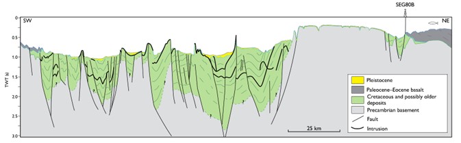
Figure 4 – Geological cross-section over the Ammassalik Basin based on the southern segment of the TGS 2012-10 seismic profile (see Fig. 3B for location). From Gerlings et al. (2017).
Kangerlussuaq Basin
The Kangerlussuaq Basin is an onshore sub-basalt Cretaceous–Paleocene basin bounded by NE- and NW-striking faults (Figs 3B, 5A; Larsen et al. 1999; Larsen et al. 2005). The basin is exposed over an area of 5000 km2 but the basin margin to the north-east is not exposed and it may continue below the thick succession of Palaeogene flood basalts exposed along the East Greenland coast further to the north. The continuation of the basin into the offshore areas is also unknown. The basin consists of predominantly NW dipping fault blocks bounded by SW–NE striking normal faults. The Sortekap Fault probably controlled the position of the north-western basin margin during the mid-Cretaceous (Aptian) and mid-Paleocene sea level lowstands. In areas south of the Sortekap Fault, crystalline basement locally crops out in windows between a cover of Cretaceous(?) sediments (Fig. 5). These basement windows probably are related to exhumed crests of tilted fault blocks.
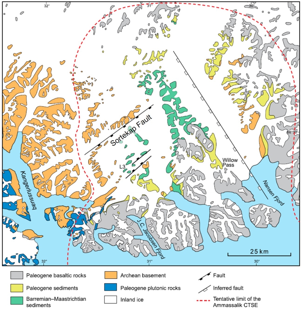
Figure 5 – Geological map of the Kangerlussuaq Basin. From Larsen et al. (2005).
The sedimentary succession is approximately 1 km thick. The oldest sediments are of Early Cretaceous age (Barremian?, Aptian – Early Albian) resting on crystalline basement (Fig. 6; Larsen et al. 1999; Larsen et al. 2005). The lower Albian-Aptian (Barremian?) succession composed of fluvial and estuarine sandstone and lacustrine mudstones. Tectonic activity during the Albian–Coniacian resulted in flooding by a monotonous succession of marine silty mudstones and fine-grained sandstones reaching several hundred metres in thickness with a rich fauna of ammonites, echinoderms and bivalves (Fig. 6; Larsen et al. 2005). An increasing number of fan and channel turbidite fan and channel sandstones occur in the unconformably overlying Maastrichtian – Lower Danian succession (Fig. 6). Another tectonic unconformity separates this succession from overlying fluvial sandstones and conglomerates, immediately predating the earliest volcanic rocks (Fig. 6).
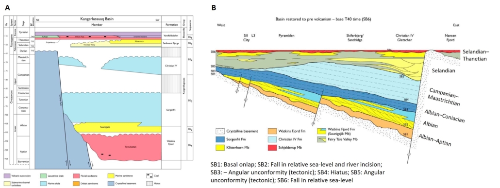
Figure 6 – A: Kangerlussuaq Basin stratigraphy. B: Cross-section of the Kangerlussuaq Basin restored to SB6 time (Late Thanetian). From Larsen et al. (2005).
The sedimentary succession has been deeply buried, potentially reaching a depth of more than 5 km (Brooks 1979) and is locally affected by intense heating from magmatic intrusions.
Kap Gustav Holm
Kap Gustav Holm is a small, hardly accessible onshore exposure covering a few km2 some 50 km north of the Ammassalik Basin (Figs 3, 7). The succession is approximately 150 m thick and is resting on basement. Locally it is heavily contact metamorphosed along an Eocene intrusion. It consists of gravels, metamorphosed shales and fossiliferous sandstones, but the accessible part is only 25–30 m thick with two submarine lava flows in the lower part. Bivalves indicate a Late Cretaceous – Early Palaeogene age of the succession, but there is room for an older ?Cretaceous succession underneath the accessible part of the outcrop.
.
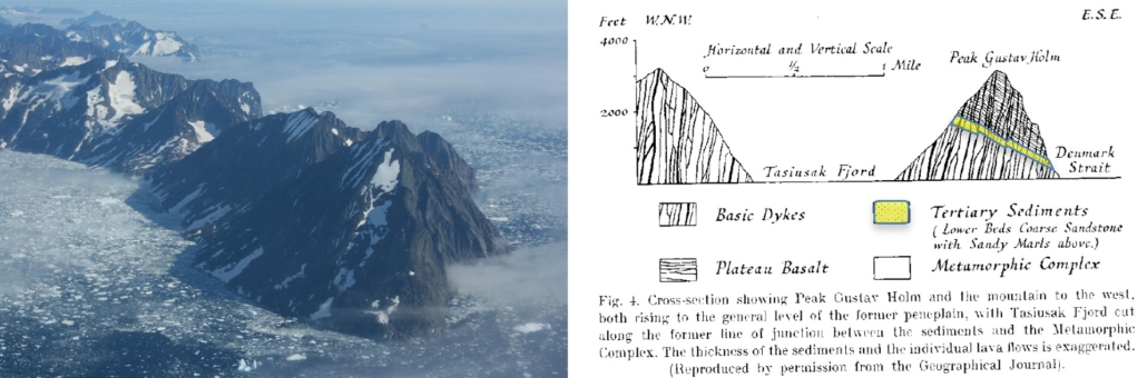
Figure 7 – The Kap Gustav Holm exposure. Cross-section from Wager (1934).
Analogue Basins
West of Shetland Basin
A structural reconstruction of the North Atlantic back to the Late Jurassic shows that the closest analogue to South-East Greenland is the offshore West of Shetland Basin north of Scotland and the Irish basins north-west of Ireland (Fig. 8).
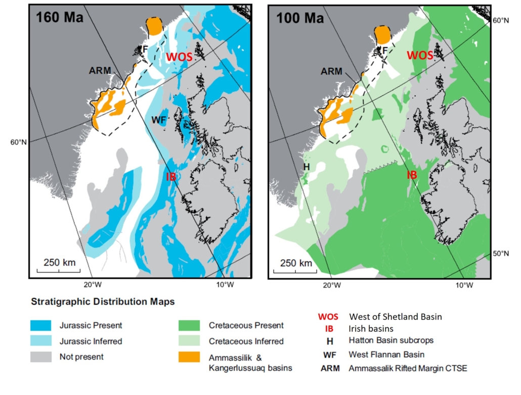
Figure 8 – Late Jurassic and Late Cretaceous plate reconstructions showing proven and inferred sedimentary basins. From Gerlings et al. (2017).
Contrary to the East and South-East Greenland basins the West of Shetland area is a mature hydrocarbon province. The known Cretaceous–Paleocene succession from the Kangerlussuaq Basin is very similar to the equivalent West of Shetland Basin succession and a detailed correlation has been made of both the Cretaceous and Paleogene successions (Figs 9, 10, 11).
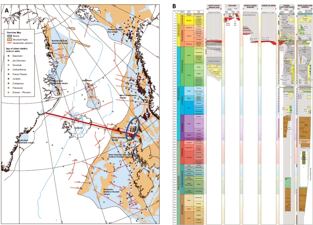
Figure 9 – Stratigraphic cross-section from Sout-East Greenland to the West of Shetland Basin. Both regions display a similar Cretaceous–Paleocene succession, but contrary to South-East Greenland, the West of Shetland Basin has a proven Devonian–Jurassic succession. From Stoker et al. (2014).
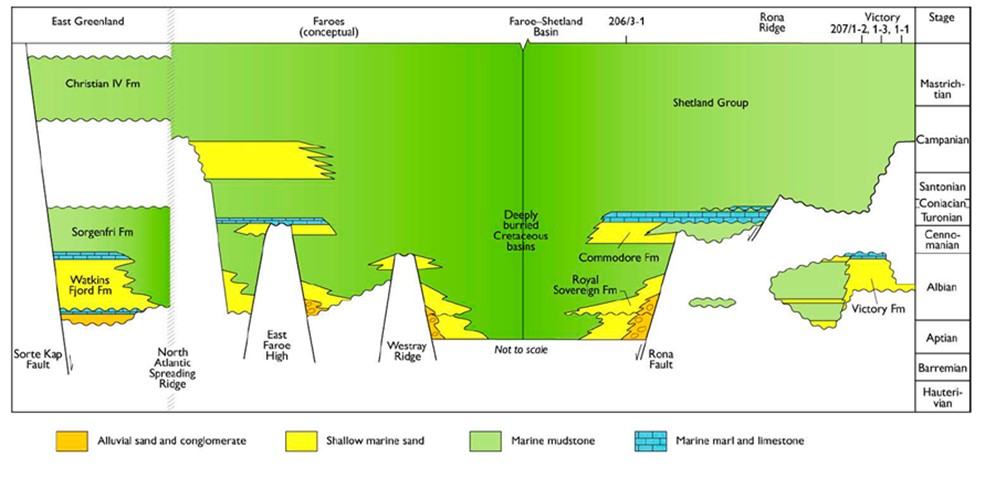
Figure 10 – Correlation of the Cretaceous succession West of Shetland and Kangerlussuaq in East Greenland. From Larsen et al. (2005).
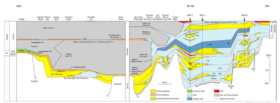
Figure 11 – Correlation of the early Palaeogene successions West of Shetland, the Faroes and in southern East Greenland. From Larsen et al. (2005).
Most of the discoveries have been made in the Cretaceous–Palaeogene succession and the cumulative commercial resource discovered by well count is showing an almost flat curve for the WoS (commercial discoveries (Fig. 12). This curve shows that the basin is close to have been creamed out and no significant discoveries can be expected to be found in the future, only if it is possible to commercialize the Fractured Basement Play that Hurricane Energy is currently testing. By 2019 the total number of exploration wells drilled West of Shetland was 151. The size of the area is c. 30,000 km2, that is 5 wells/1000 km2. By 2019 the total discovered commercial resources was 2.6 BBOE distributed on 13 commercial discoveries. In addition, 2.4 BBOE of technical (non-commercial) discoveries have been made by 29 wells, which results in a commercial success rate of 8.6% and technical success rate of 28%. The average discovery size is 119 MMBOE recoverable. Thus, the area yield is 167 MMBOE/1000 km2. These numbers are used in the evaluation of the Yet-to-Find in the Ammassalik Basin.
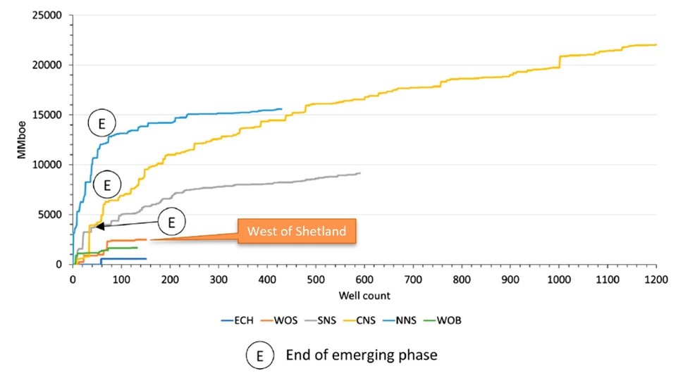
Figure 12 – Cumulative commercial resource discovered by well count for each of the UKCS areas. The approximate ends of the emerging phase has been annotated for the Central North Sea (CNS), Northern North Sea (NNS) and Southern North Sea (SNS). ECH, English Channel; WOS, West of Shetland; WOB, West of Britain. Source: Westwood Global Energy, Atlas Service. From Rouillard et al. (2020).
Irish Basins
.
The offshore Irish basins are only partly explored with 160 explorations wells drilled. Four commercial gas discoveries have been made – all in the Celtic Sea Basin south of Ireland. Offshore NW Ireland one commercial gas discovery has been made and three uncommercial discoveries are reported from the Porcupine Basin west of Ireland. Source rock characteristics are generally poorer, especially for the Jurassic source rock, than in the West of Shetland Basin. The information from the Irish basins has therefore only been used in the assessment of risk of charge in AU6.
Petroleum Systems
The Kangerlussuaq Basin formed during Early – mid Cretaceous rifting with evidence of several phases of rifting. The succession includes shallow marine mid-Cretaceous (Albian–Aptian), Selandian turbidite, Thanetian shallow marine and fluvial Thanetian–Ypresian reservoir units. Several internal sealing units of Albian–Maastrichtian and Selandian–Thanetian age exists, and rotated faults blocks along the NE-SW trending faults provide the possibility for large structural traps.
All these elements of the petroleum systems are proven in the basins on the conjugate margin along the Norwegian, Faeroese, and British continental shelves. Most of the proven North Atlantic basins have been sourced by the Late Jurassic – Early Cretaceous source rock (Kimmeridge Clay equivalent). The main challenge for the petroleum system offshore South-East Greenland is the lack of proven source in the Kangerlussuaq Basin. Jonk et al. (2005) reported petroleum-bearing fluid inclusion in three samples collected from the Cretaceous–Palaeogene succession of the Kangerlussuaq Basin. The source for these oil inclusions is unknown but appears to be an Aptian estuarine mudstone. The fluid inclusions suggest that oil was trapped at temperatures of more than 108°C indicating a burial depth of 3 km or more. The data suggest that the sandstones may serve as migration conduits if adequately charged.
In the Ammassalik Basin eight gravity cores collected by Volcanic Basin Petroleum Research AS (VBPR) and TGS in 2012 are reported to show evidence of petroleum seepage (VBPR 2012, proprietary report). One sample approximately 1 m below surface stands out by showing well-developed distribution of n-alkanes. Age-diagnostic NDR-data point to a Jurassic age and was interpreted to indicate a Jurassic-aged seepage. Although the analytical quality is impeccable, interpretations appear somewhat copious and would benefit from supporting evidence. Therefore, the presence of thermogenic petroleum can neither be unambiguously confirmed, nor ruled out.
A remote sensing study by Vis (2017), using synthetic aperture radar (SAR) data suggest the presence of oil slicks in three areas off East Greenland, including the area offshore the Kangerlussuaq Basin. The seeps in AU6 are situated in areas with thick basaltic cover or seaward of the continent–ocean boundary and therefore probably indicate the presence of a possible Cenozoic source rocks.
Onshore indications of viable petroleum systems in AU5 north of AU6 include a variety of examples of oil-staining/seepage recorded in both fully cored boreholes and in outcrops. These various occurrences can be classified as (1) associated with a mature source rock in immediate vicinity to the stain; (2) migrated, i.e. not associated with a known nearby source rock; (3) associated with mineralisations; (4) gas seeps (see Christiansen & Bojesen-Koefoed 2021 for locations and references).
Source-associated stains generated from the Middle Devonian are found at Ankerbjergselv; from the Permian at Kap Stosch, Margrethedal and Wegener Halvø; from the Carnian at Mols Bjerge; from the Upper Jurassic in the Sjællandselv and Blokelv boreholes; from the Cretaceous in the Nanok-1 borehole and in outcrops near to the wellsite (Bojesen-Koefoed et al. 2020).
Migrated oil traces that cannot be readily associated with a local source are found in Tobiasdal, Savoia Halvø, Kap Dalton and in the so-called exhumed oilfields on Traill Ø and Geographical Society Ø.
Mineralisation-associated bitumen, so-called carburan, is found in Randbøldal and gas seeps are found in Coloradodal and Rømer Fjord.
.
Potential petroleum source rocks in AU5 include a total of ten units of which the five most important are of Devonian, Carboniferous, Late Permian, Late Triassic – Early Jurassic and Late Jurassic – Early Cretaceous age (see Dam et al. 2022 for discussion and properties).
The principal Upper Jurassic – Lower Cretaceous petroleum source rocks, equivalents of the main source rocks of the greater North Sea Petroleum Province and the Barents Sea, are widely distributed and exposed in East and North-East Greenland and would probably be the most likely source rocks for the Ammassalik Basin, if present.
Because of the lack of source rock data and the inability to break the Ammassalik Basin into tectono-stratigraphic sequences, basin modelling has not been performed.
Assessment Process
The assessment process for the resource evaluation of AU4 is summarised in the “Yet-To-Find Triangle” shown in Figure 13. Basin evaluation is the basic activity describing the structural and stratigraphic framework leading into construction of Gross Depositional Environment (GDE) maps and identification of source rocks, reservoirs and regional seals that form the basis for definition of the plays.
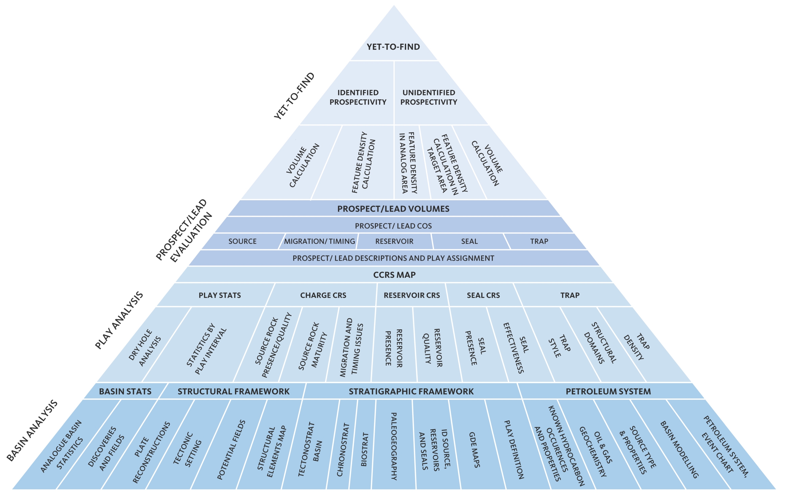
Figure 13 – Resource evaluation workflow used in the Greenland Resource Assessment.
The results from the Basin Evaluation feed into the Play Analysis. In this analysis, numeric Common Risk Segment (CRS) and Composite Common Risk Segment (CCRS) maps have been constructed based on all available geological and geophysical data.
The risking schemes used in Assessment Units 1–5 cannot be used in AU6 (South-East Greenland) due to the very low data density. Risking therefore heavily relies on knowledge from the conjugate margin, i.e. West of Shetland area, where exploration activity has been intense.
Due to the lack of data risking is not carried out on individual plays but only on general, overall level.
The following play risk elements have been assessed (see presentation for details):
- Reservoir presence: Presence of at least one effective reservoir unit in the subsurface with a possible connection to source.
- Reservoir effectiveness: Anticipated burial of possible reservoir unit corrected for uplift and possibility of degrading intrusions.
- Top seal effectiveness: Overburden thickness, modified in areas with large amount of uplift.
- Trap presence: Possibility to acquire high-quality data.
- Charge: Outcrop data or knowledge from conjugate margin (possible presence of uppermost Jurassic source).
Gas risk has not been assessed and all volumes are in MMBOE. For analysis on volumetrics of individual phases, more detailed analysis and mapping must be carried out.
Resource Assessment
The resource assessment provides an estimate of the play-based Yet-to-Find potential of conventional hydrocarbons. As mentioned above, the assessment is only carried out on a general, overall level and no known prospectivity can be included.
The Yet-to-Find analysis is based on a feature (lead) density calculation approach. Due to the scarcity of data and the lack of mapped features in Assessment Unit 6 the Yet-to-Find assessment solely relies on analogue data from the closest exploration areas on the North-East Atlantic conjugate margin, i.e. West of Shetland and the Irish offshore basins.
The Mean Risked Recoverable of AU6 is:
Sum of:
[SegmentArea*FD*MFV*AU6TotalRiskOverall(per area)]
The West of Shetland region (~30,000 km2) is regarded to be almost fully explored by now. 151 exploration wells (features) have been drilled corresponding to a feature density (FD) of 5/1000 km2. The total amount of resources (commercial and technical) amounts to 5.0 BBOE from 42 wells corresponding to an average unrisked discovery size (mean feature volume – MFV) of 119 MMBOE per well.
The total risked Yet-to-Find of AU6 is thus 1722 MMBOE (Fig. 14 and Table 1).
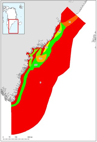
Figure 14 – Risked recoverables in MMBOE for the various segments in AU6.
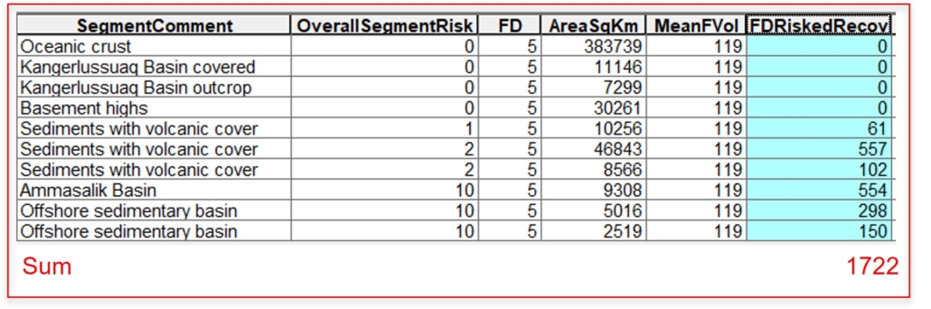
Table 1 – Risked recoverables in MMBOE for the various segments of AU6.
Table 1 – Risked recoverables in MMBOE for the various segments of AU6.
Deliverables
The results from this study including a Player® ArcGIS project and an extensive slide pack are available for the petroleum exploration industry by contacting Thomas Varming at NUNAOIL.
References
Bojesen-Koefoed, J. A., Bjerager, M., Nytoft, H. P., Petersen, H. I., Piasecki, S. & Pilgaard, A. 2018: Petroleum potential of the Upper Jurassic Hareelv Formation, Jameson Land, East Greenland Geological Survey of Denmark and Greenland Bulletin 42, 85-113. https://doi.org/10.34194/geusb.v42.4314
Brooks, C. K. 1979: Geomorphological observations at Kangerdlugssuaq, East Greenland. Meddelelser om Grønland, Geoscience 1, 24 pp. https://doi.org/10.34194/geusb.v47.6519
Christiansen, F. G. & Bojesen-Koefoed, J. A. 2021: Inventory of onshore petroleum seeps and stains in Greenland: a web-based GIS model. GEUS Bulletin 47, 1-20. https://doi.org/10.34194/geusb.v47.6519
Christiansen, F. G., Larsen, H. C., Marcussen, C., Piasecki, S. & Stemmerik, L. 1992: Late Paleozoic plays in East Greenland. Geological Society, London, Petroleum Geology Conference Series 4, 657-666. https://doi.org/10.1144/0040657
Dam, G., et al. 2022: Greenland Resource Assessment, Assessment Unit 5 – Central East Greenland. Project Summary. Online only. 2022, 24 pp. https://greenland-resource-assessment.gl/wp-content/uploads/2022/04/Greenland-Resource-Assessment-AU5-Project-Summary.pdf
Fyhn, M. B. W., Hopper, J. R. & Gerlings, J. 2021: Ammassalik Composite Tectono-Sedimentary Element, southern East and SE Greenland rifted margin, Denmark Strait. Geological Society, London, Memoirs 57. https://doi.org/10.1144/M57-2016-8
Gerlings, J., Hopper, J. R., Fyhn, M. B. W. & Frandsen, N. 2017: Mesozoic and older rift basins on the SE Greenland shelf offshore Ammasalik. Geological Society, London, Special Publications 447, 375–392. https://doi.org/10.1144/SP447.15
Goffey, G., Gluyas, J. & Schofield, N. 2020: UK oil and gas fields: an overview. In: Goffey, G. & Gluyas, J. (eds): United Kingdom oil and gas fields: 50th anniversary cmmemorative volume. Geological Society, London, Memoirs 53, 3–18. https://doi.org/10.1144/M52-2019-48
Haase, C. & Ebling, J. 2014: Chapter 3: Gravity data. In: Hopper, J. R., et al. (eds): Tectonostratigraphic atlas of the North-East Atlantic regions, 29–39. Copenhagen: Geological Survey of Denmark and Greenland. https://doi.org/10.22008/FK2/ZZQRQ1
Ineson, J. R. & Bojesen-Koefoed, J. A. 2018: Petroleum geology of the Upper Jurassic – Lower Cretaceous of East and North-East Greenland: Blokelv-1 borehole, Jameson Land Basin. Geological Survey of Denmark and Greenland Bulletin 42, 168 pp. https://geusbulletin.org/index.php/geusb/issue/view/271
Jonk, R., Parnell, J. & Whitham, A. 2005: Fluid inclusion evidence for a Cretaceous–Palaeogene petroleum system, Kangerlussuaq Basin, East Greenland. Marine and Petroleum Geology 22, 319-330. https://doi.org/10.1016/j.marpetgeo.2005.01.002
Larsen, M., Hamberg, L., Olaussen, S., Nørgaard-Pedersen, N. & Stemmerik, L. 1999: Basin evolution in southern East Greenland: An outcrop analog for Cretaceous–Paleogene basins on the North Atlantic volcanic margins. AAPG Bulletin 83, 236-1261. https://doi.org/10.1306/E4FD3347-1732-11D7-8645000102C1865D
Larsen, M., Nøhr-Hansen, H., Whitham, A. G. & Kelly, S. R. A. 2005: Stratigraphy f the pre-basaltic sedimentary succession of the Kangerlussuaq Basin. Volcanic basins of the North Atlantic. Final report for the Sindri Group. Danmarks og Grønlands Geologiske Undersøgelse Rapport 2005/62, 142 pp. https://doi.org/10.22008/gpub/26006.
Requejo, A. G., Hollywood, J. & Halpern, H. I. 1989: Recognition and source correlation of migrated hydrocarbons in Upper Jurassic Hareelv Formation, Jameson Land, East Greenland. AAPG Bulletin 73, 1065-1088. https://doi.org/10.1306/44B4A53C-170A-11D7-8645000102C1865D
Rouillard, P., Bagley, G., Moseley, D., Myers, K. & Harding, A. 2020: UKCS exploration: 50 years and counting. Geological Society, London, Memoirs 52, 32-42. https://doi.org/10.1144/M52-2018-66
Stoker, M., Doornenbal, H., Hopper, J. R. & Gaina, C. 2014: Chapter 7: Tectonostratigraphy. In: Hopper, J. R., et al. (eds): Tectonostratigraphic atlas of the North-East Atlantic region, 129–212. Copenhagen: Geological Survey of Denmark and Greenland. https://doi.org/10.22008/FK2/ZZQRQ1
Strogen, D. P., Burwood, R. & Whitham, A. G. 2005: Sedimentology and geochemistry of Late Jurassic organic-rich shelfal mudstones from East Greenland: regional and stratigraphic variations in source-rock quality. In: Doré, A. G. & Vining, B. A. (eds): Petroleum geology: North-West Europe and global perspectives – Proceedings of the 6th Petroleum Geology Conference. Geological Society, London, Petroleum Geology Conference Series 6, 903–912. https://doi.org/10.1144/0060903
Surlyk, F. 1987: Slope and deep shelf gully sandstones, Upper Jurassic, East Greenland. AAPG Bulletin 71, 464–475. https://doi.org/10.1306/94886ecf-1704-11d7-8645000102c1865d
Surlyk, F. 2003: The Jurassic of east Greenland: a sedimentary record of thermal subsidence, onset and culmination of rifting. Geological Survey of Denmark and Greenland Bulletin 1, 659-722. https://doi.org/10.34194/geusb.v1.4674
Surlyk, F. & Noe-Nygaard, N. 2001: Sand remobilisation and intrusion in the Upper Jurassic Hareelv Formation of East Greenland. Bulletin of the Geological Society of Denmark Special Issue(48), 169-188. https://doi.org/10.37570/bgsd-2001-48-10
Vis, G.-J. 2017: Geology and seepage in the NE Atlantic region. Geological Society, London, Special Publications 447, 443-455. https://doi.org/10.1144/SP447.16
Wager, L. R. 1934: Geological investigations in east Greenland. Pt.1. General geology from Angmagsalik to Kap Dalton. Meddelelser om Grønland 105(2), 46 pp.