PROJECT SUMMARY
Greenland Resource Assessment, Baffin Bay
(Assessment Unit 2)
Executive Summary
A play-based resource assessment of conventional hydrocarbons has been performed for the Baffin Bay continental shelf area, West Greenland (Assessment Unit 2, AU2). Four play levels have been assessed, with an estimated mean for the undiscovered resources of ~9,100 MMBOE risked recoverable.
The known prospectivity includes 106 leads with Mean Case Risked Recoverables volumes of ~2350 MMBOE. The unidentified prospectivity has Mean Case Risked Recoverables volumes of ~6750 MMBOE resulting in an average area yield of ~70 MB/1000 km2 (risked). The unrisked Pmean volumes for the leads of the four evaluated play levels range from 5 to 4000 MMBOE.
The geologic probabilities for AU2 were determined based on careful play mapping constructing a series of numeric CRS (Common Risk Segment) maps and CCRS (Composite Common Risk Segment) maps of the assessment area. In this manner, the probabilities are consistently applied throughout the area for both the known and unknown prospectivity.
The assessment results presented are based on all available data collected and interpreted by the industry, GEUS, NUNAOIL and the Greenland Ministry of Foreign Affairs and Energy (MFAE) and reflect the state of geologic knowledge of the West Greenland part of the Labrador Sea – Davis Strait area at the time of the assessment. Any future drilling and evaluation of the petroleum systems and plays based on new data within this area will add to the geologic knowledge and will therefore lead to a refinement of these assessment results.
The assessment was carried out using the Player® GIS software provided by GIS-pax. The methodology and results of the assessment have been quality controlled by the Norwegian Petroleum Directorate and GIS-pax.
The results of this study are reported in an extensive ArcGIS project supported by a comprehensive slide package which includes 11 presentations, reflecting the workflow of the project, including:
- Introduction
- Database
- Structural Framework
- Seismic-Stratigraphic Framework
- Stratigraphic Evolution
- Petroleum Systems
- Post-Well Analysis
- Plays Analysis
- Lead Overview
- Input Parameters
- Yet-to-Find Analysis
The Player and ArcGIS projects together with the slide pack are available for the petroleum exploration industry at no cost and can be downloaded from the project website.
Introduction
The AU2 Resource Assessment (Baffin Bay, West Greenland) is the second of seven assessments of the “Whole-of-Greenland Petroleum Resource Assessment Project” covering the entire Greenland continental shelf (Fig. 1). The aim of the project is to provide an estimate of a quantitative, play-based Yet-to-Find potential of conventional hydrocarbons on the Greenland continental shelf.
The project is carried out to facilitate business decisions and guide the industry towards the most prospective areas, as well as helping the Greenland Authorities and politicians in strategic decision making and in planning for future licensing rounds. In addition, it will support the definition of new G&G de-risking initiatives.
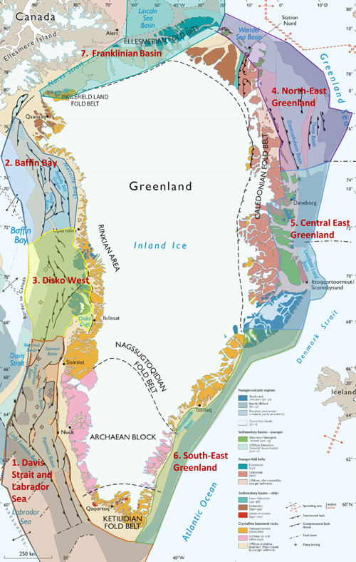
Figure 1 – Geological map of Greenland with the seven assessment units indicated.
The project is mainly sponsored by NUNAOIL and is carried out as a collaboration between GEUS, NUNAOIL and the Greenland Ministry of Foreign Affairs and Energy (MFAE) hosted by GEUS. The work is based on all available existing data provided by the industry, GEUS, NUNAOIL and MFAE. Furthermore, it includes a regional basin modelling study, carried out in-house at GEUS. The results will be reported as the work on the individual assessment units are finalized.
A hydrocarbon resource assessment of the Greenland continental shelf north of the Arctic Circle has previously been performed as part of the U.S. Geological Survey (USGS) Circum-Arctic Resource Program (Schenk 2011; Moore & Gautier 2017). This assessment, however, used a probabilistic approach heavily relying on analogue modelling comparing the Arctic assessment units with similar but geologically better understood and better calibrated petroleum provinces elsewhere in the world. The study therefore only provided a broad overview of the possible resource potential within the assessment units of the study.
Database
The database for AU2 includes an extensive 2D seismic data set of various vintages, three 3D seismic surveys, magnetic and gravity surveys, data from 11 stratigraphic boreholes (Acton et al., 2012) as well as numerous scientific publications and industry reports. Furthermore, excellent outcrop analogues occur in the onshore Nuussuaq Basin, at Cape Dyer, and on Bylot Island and Ellesmere Island (Figs 2, 3).
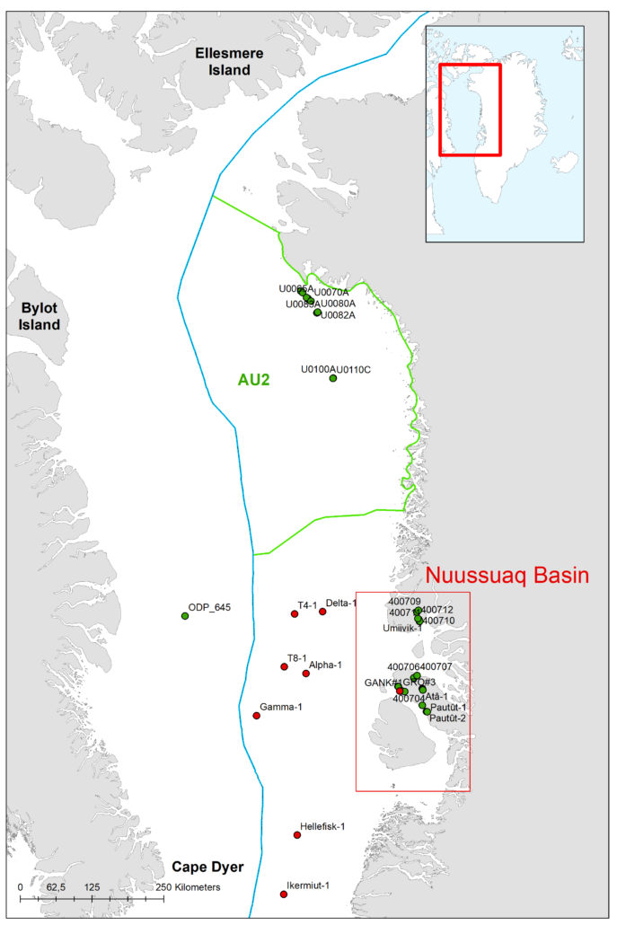
Figure 2 -Outline of AU2 and Nuussuaq Basin and locations of exploration wells (red) and stratigraphic boreholes (green).
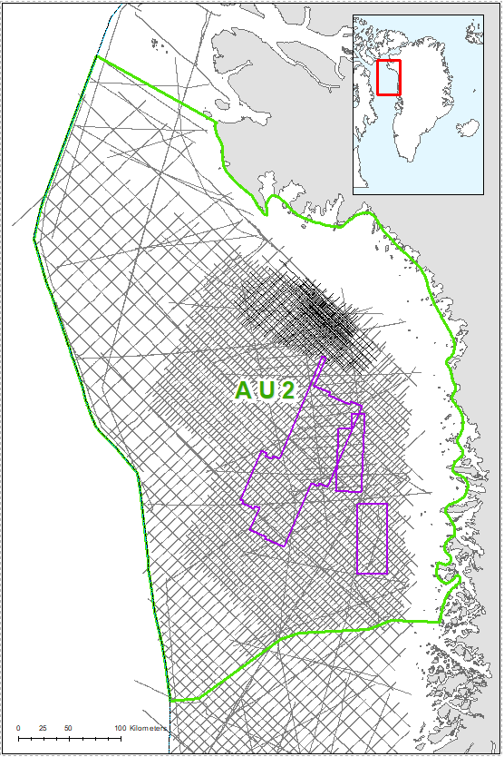
Figure 3 – Seismic database of AU2. Purple outline shows extent of 3D surveys.
Exploration History
No exploration drilling have been carried out in Baffin Bay and the area is characterized as a frontier exploration region. Exploration efforts in West Greenland have been restricted to five periods (Christiansen 2011):
-
- An offshore campaign offshore south-west Greenland in the 1970s with extensive seismic acquisition and drilling of five exploration wells in the shallow-water areas – drilling operators were Total, Mobil, Chevron, and ARCO
- An onshore programme on Disko–Nuussuaq onshore central West Greenland by a small Canadian company grønArctic in the 1990s including drilling of the GRO#3 exploration well
- Offshore exploration in the 1990s offshore southwest and central West Greenland by Statoil, Phillips, DONG and NUNAOIL, including drilling of the Qulleq-1 exploration well in 2000
- New activities in the 2000s offshore West Greenland with a high level of seismic data acquisition by the seismic industry followed by a large number of licence awards and drilling of 8 exploration wells by Cairn in 2010-11
- A major campaign in the Baffin Bay area in the 2010s with drilling of 11 shallow core boreholes (Figs 2 and 4) and extensive seismic acquisition including acquisition of 3D seismic data
Following the collapse of the oil price in 2014, most licences were relinquished, and exploration activities have almost ceased.
Fifteen exploration wells have been drilled in West Greenland, but no commercial discoveries have been made.
Figure 4 summarizes the post-well analysis of the 11 stratigraphic boreholes drilled in AU2.
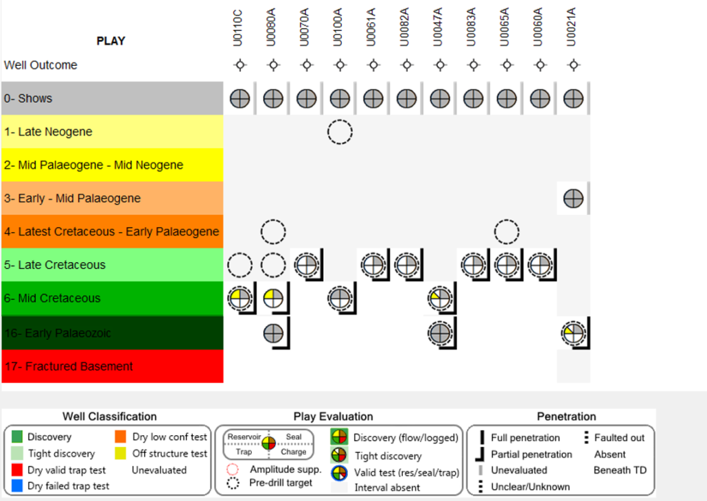
Figure 4- Post well analysis of stratigraphic boreholes drilled in AU2.
Seismic-Stratigraphic Interpretation
The regional seismic stratigraphic interpretation is based on GEUS and NUNAOIL in-house interpretation. Ten super-regional seismic stratigraphic key horizons have been mapped and tied to the shallow core wells and assigned to plays (Figs. 5, 6). The ten regional seismic stratigraphic key horizons that have been mapped are: A1: Seabed; B1: Plio-Pleistocene/Base Quaternary; C1: Late Miocene
Unconformity; D1: Mid-Miocene Unconformity; E1: Mid-Eocene Unconformity; EV: Top Volcanics; F1: Near base Cenozoic Unconformity; G1: mid-Cretaceous unconformity; H1: Near base Cretaceous and Hx: Basement (Fig. 5).
In addition, other horizons have locally been used in AU2: Eo/Ex: Top Oceanic crust and Transition zone; Ew: Top Kivioq West Volcanic Region including two volcanoes; F2: Intra Turonian; F3: Cenomanian-Turonian; H2: Intra Proterozoic Thule Supergroup.
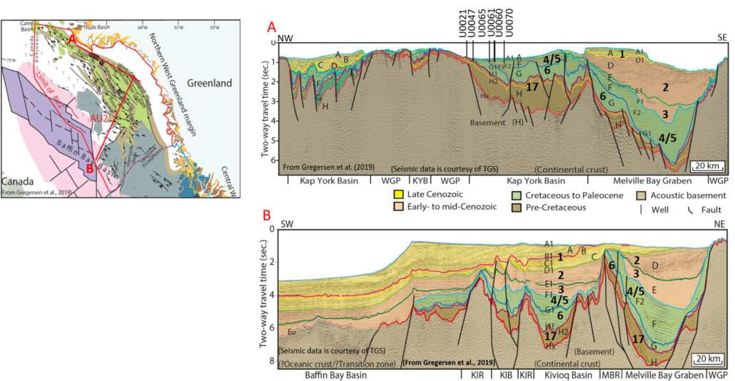
Figure 5 – Seismic sections with well-ties of the seismic stratigraphic horizons, tectono-stratigraphic mega-units (F-H; modified from Gregersen et al., 2019).
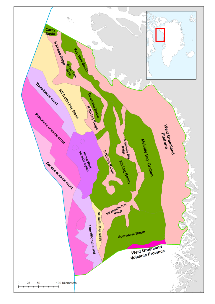
Figure 6 – Structural elements map of Baffin Bay. The eastern part of the margin is dominated by Cretaceous rift basins covered by Palaeogene deposits. Further west in the region volcanic rocks and oceanic crust constitute the deeper geology. Map modified from Gregersen et al. (2019).
Tectonostratigraphic Evolution
The tectonic evolution of the Labrador Sea – Davis Strait – Nuussuaq – Baffin Bay region is complex involving multiple phases of rifting related to the initial opening of the norther Atlantic, transpressional movements, counter-clockwise rotation of Greenland, causing Late Paleocene – Early Eocene compression and inversion followed by Neogene – late Neogene uplift of the margins (e.g. Chalmers et al. 1999; Chalmers & Pulvertaft 2001; Dam et al. 1998, 2009; Funck et al. 2007; Gregersen et al. 2019; Japsen et al. 2005; Knutsen et al. 2012; Nielsen et al. 2011; Oakey & Chalmers 2012; Pedersen et al. 2018, 2019). Furthermore, the central West Greenland area is strongly affected by the North Atlantic Mantle Plume causing thermal uplift and subsequent drifting.
In the Baffin Bay region major basins of Cretaceous age are separated by structural highs: the Kap York Basin, Kivioq Basin, Melville Bay Graben, Upernavik Basin, and several smaller basins (Fig. 6). Towards the west in central Baffin Bay a thick, possibly Paleocene volcanic succession extruded during initial sea floor spreading Kiviaq West volcanic region). Oceanic or transitional crust is found in the central part of Baffin Bay (Fig. 6).
Six major tectonostratigraphic phases have been recognized offshore West Greenland (Fig. 7; Gregersen et al. 2019).

Figure 7 – Tectonostratigraphic evolution of West Greenland. From Gregersen et al. (2019).
The Pre-rift Phase includes Proterozoic and Palaeozoic successions.
The ?Aptian/Albian – earliest Cenomanian Early-rift Phase is characterized by the development of large extensional fault blocks and deposition of alluvial and lacustrine sediments.
A marine drowning episode separates the sediments of Early Rift Phase from the early Cenomanian – Early Campanian Subsidence (local rifting) Phase. This phase was characterized by deposition of marine muds and sands. The presence of a volcano of Late Cenomanian – Early Turonian age in the Nuuk Basin indicates that local rifting took place during the early stage of this phase (Knudsen et al., 2020).
A change in stress regime occurred during the initiation of the Early Campanian – Early Paleocene Late Rift Phase and in central West Greenland, the arrival of the North Atlantic Mantle Plume resulted in major uplift, erosion, and canyon incision. The Late Rift Phase was characterized by development of large deep-water basins and deposition of reservoir sands took place in basin-floor fans, turbidite slope channels and large canyons.
During the Early Paleocene – Eocene Drift Phase, formation of oceanic crust took place, causing separation of the continental margins of Greenland and Canada with north-east to northward movement of Greenland. From Paleocene to Eocene the central West Greenland Cretaceous – Early Paleocene basins were covered by volcanic rocks of the North Atlantic Igneous Province while deep marine deposition
took place in the Baffin Bay basins. Formation of oceanic crust was associated with compressional tectonics and the development of strike-slip and thrust faults, pull-apart basins, and inversion structures, most pronounced in the Davis Strait and Baffin Bay regions.
During the late Cenozoic – present-day Post-drift Phase tectonism diminished, though some intra-plate vertical adjustments occurred, and a series of uplift events took place along the passive margins. The latest basin development was characterized by formation of thick Neogene to Quaternary marine successions including contourite drifts and glacial related shelf progradation towards the west and south-west.
Plays and Play Elements
Based on seismic interpretation, well and outcrop data, 17 plays have been established for all seven assessment areas of the Greenland continental shelf. Seven of these plays are present in AU2 (Plays 1-6 and 17; Fig. 7). Six source rocks have been documented on the West Greenland continental margin and reservoir rocks are present virtually at all stratigraphic levels. High-quality regional seals are well documented in Cenomanian-Turonian, Campanian and Paleocene shales (Fig. 7).
Petroleum Systems
Six possible source rocks have been documented from geochemical analyses of oil seeps and mudstones in outcrops, dredge samples and well cores along the West Greenland continental margin (Bojesen-Koefoed 2011; Bojesen-Koefoed et al. 1999). Source rock intervals include Ordovician, Albian, Cenomanian–Turonian, Campanian, Paleocene–Eocene and Miocene. Several of these source rocks are also proven in eastern Canada from outcrops on Ellesmere Island, oil seepage in Scott Inlet and wells on the south-east Baffin Bay and Labrador continental shelves (Balkwill et al. 1990; Núñez-Betulu 1993; Fowler et al. 2005). The oil seeps described from the onshore Nuussuaq Basin and offshore East Canada, the Kangâmiut-1 gas kick and the gas discoveries on the East Canadian continental shelf provide evidence that, at least in those areas, petroleum systems are or have been active.
In Baffin Bay, however, only the Albian, Cenomanian-Turonian and Paleocene source rocks are expected to contribute to hydrocarbon generation. The presence of Albian and Cenomanian-Turonian source rocks have been proved by the Baffin Bay stratigraphic boreholes. The source rock characteristics of each of the three expected source rocks are summarized in Table 1.
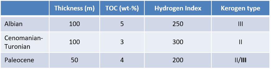
Table 1. Characteristics of the three expected source rocks in AU2.
These data have been used as input parameters to the kinetic model in the basin modelling study for the AU2 area.
Basin modelling indicates that these may have reached thermal maturity throughout or in parts of AU2. Consequently, the charge model for the play analysis incorporates the possibility for charge from all three mature source rock intervals.
Assessment Process
The assessment process for the resource evaluation of AU2 is summarised in the “Yet-To-Find Triangle” shown in Figure 8. Basin evaluation is the basic activity describing the structural and stratigraphic framework leading into construction of Gross Depositional Environment (GDE) maps and identification of source rocks, reservoirs and regional seals that form the basis for definition of the plays. IES PetroMod v16.2 has been used to compile and setup a 3D basin reference model to assess maturity and possible migration for expected source rock intervals.
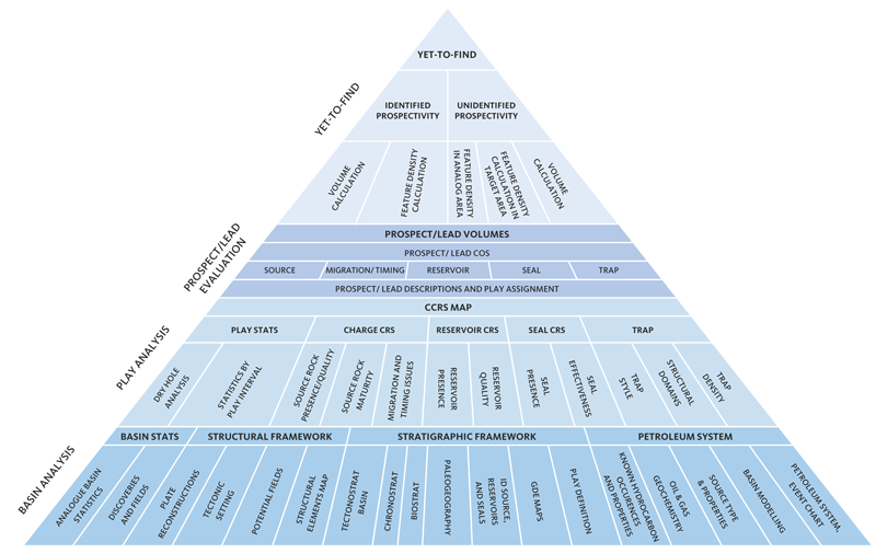
Figure 8 – Resource evaluation workflow used in the Greenland Resource Assessment.
The results from the Basin Evaluation feed into the Play Analysis. In this analysis, numeric Common Risk Segment (CRS) and Composite Common Risk Segment (CCRS) maps have been constructed incorporating all available geological and geophysical data and exploration history data.
The following play risk elements have been assessed: Reservoir Presence (based on GDE maps), Reservoir Effectiveness (based on depth to interval maps), Seal Effectiveness (based on overburden thickness maps) and Charge-Migration (based on maturity and drainage maps), and Trap Presence (based on seismic line density).
A multiple charge scenario is applied for each play since three source rock intervals have been identified on the West Greenland shelf: Albian, Cenomanian–Turonian and Paleocene (Bojesen-Koefoed 2011). This means that for each play a specially designed composite charge workflow is applied to assess the charge-migration risk. A detailed description of this process is found in the PowerPoint presentations available on the data portal.
Volumes for leads mapped by the industry, GEUS and NUNAOIL have been integrated into the play evaluation and the identified
prospectivity has been calculated. For the volume calculations of individual leads the oil-water contact has been picked halfway between the top of the structure and spill point, since source rock quality analysis does not support fill-to-spill scenarios. The Yet-to-Find analysis is
based on a feature (lead) density calculation approach for each of the identified play intervals calibrated with data from the most extensively explored previous licence areas (analogue areas) in AU2.
Based on these analogue areas the unidentified prospectivity has been calculated for the underexplored areas. Having calculated both identified and unidentified prospectivity, the Mean Case Risked MMBOE Recoverable per unit area can be estimated and the roll-up of all play intervals provide the Total Mean Case Risked MMBOE for AU2. In this way, information on which blocks are the most prospective is now available.
Resource Assessment
The resource assessment provides an estimate of the play-based Yet-to-Find potential of conventional hydrocarbons. The assessment includes Plays 3, 4, 5 and 6 (Fig. 7). Plays 1 and 2 are located at very shallow depths below seabed and are therefore not considered prospective.
Known Prospectivity
The first step in the Yet-to-Find Assessment was to make Gross-Rock Volumes for the leads mapped by the industry, GEUS and NUNAOIL in AU2. A total of 106 leads have been evaluated in Assessment Unit 2 (Fig. 9). Gross-Rock Volume calculations were made in Player® based on area-depth pairs from the top of structure to spill-point. Area-depth pairs were derived from either mapping of the structures in Petrel or digitizing of closure and contour lines in ArcGIS from company reports. For identified structures without area/depth pairs (unevaluated leads), area yield values have been applied.
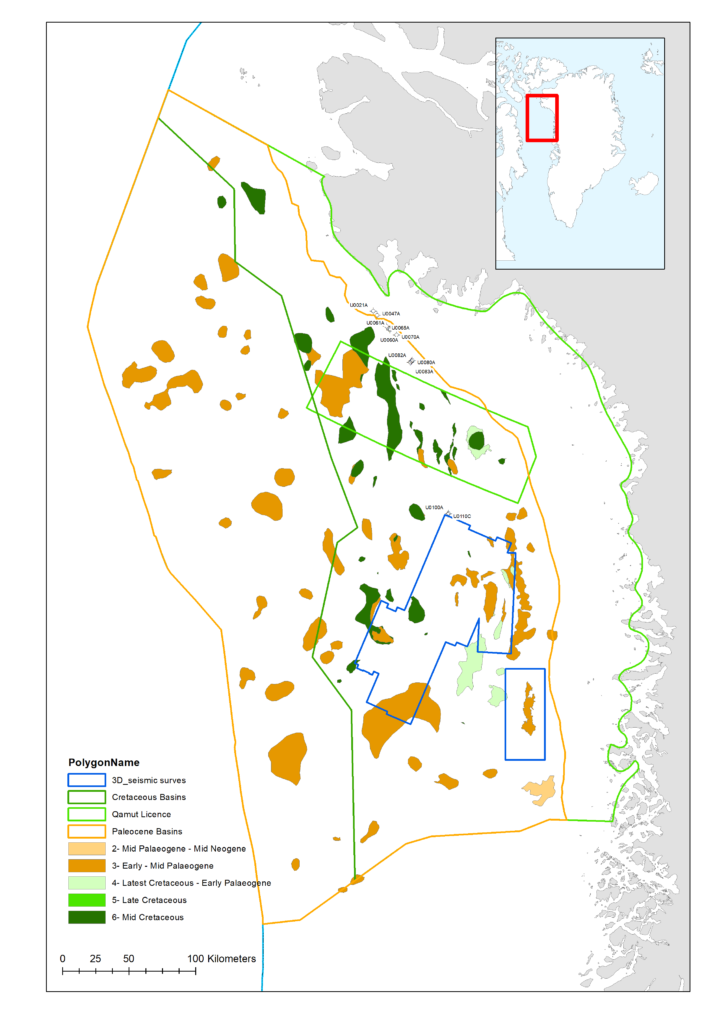
Figure 9 – Identified leads in AU2. Analog and target areas for the Yet-to-Find calculations are also shown.
For the hydrocarbon volume calculations the following input parameters have been considered for all leads: 1) Porosity, 2) Gross and net sand thicknesses and Net-to-Gross Ratio, 3) Oil Saturation, 4) Oil formation volume factor (Bo), 5) Recovery Factor (RF), and 6) Gas expansion factor (E). These input parameters are based on well data, information about water depths, interpretation of petrophysical well-logs, saturation curves, and information from publications etc.
The known prospectivity appears from integrating the calculated identified lead volumes (see section above) with the CCRS maps providing the risked volumes for the leads.
Unidentified Prospectivity
The unidentified prospectivity analysis is based on a Feature Density (FD) calculation approach for each of the identified play intervals, calibrated with data from the most extensively explored previous licence areas in Assessment Unit 2 (Fig. 9).
The most extensively explored areas (analog areas) in AU2 are the:
- Qamut Licence, 9493 km2
- Areas covered by 3D seismic data, 11,670 km2
The “Future Target Area FD (per play)” = “Analog Area (FD)” ÷ “Identified Target Area FD”.
Target area for Plays 4-6 is the area underlain by Cretaceous basins. The target area for Play 3 is the entire region west of the West Greenland Platform.
The unidentified prospectivity is the “Future Target Area FD (per play)” × “Mean volume per Feature MMBOE)”.
A summary of the results by Play Interval (Identified Prospectivity) and results by Play Interval (Unidentified Prospectivity) is shown in Table 2.
Table 2. Summaries of Identified and Unidentified Prospectivity in Assessment Unit 2. The Total Risked Recoverable (Mean Case) is 9,100 MMBOE.
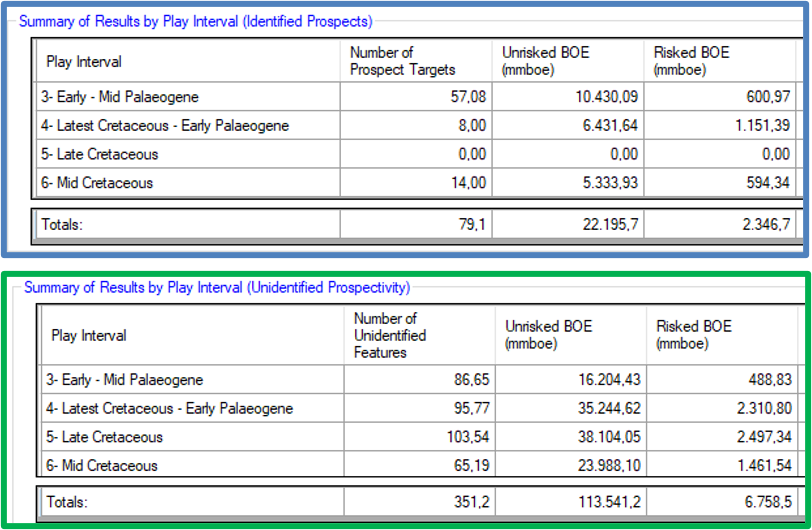
Table 2. Summaries of Identified and Unidentified Prospectivity in Assessment Unit 2. The Total Risked Recoverable (Mean Case) is 9,100 MMBOE.
Portfolio Analysis
Main basic assumptions for Yet-To-Find and Portfolio analyses:
- Stratigraphic traps and fractured basement are not considered due to high risk associated with these trap types. Such traps generally represent unique opportunities that are difficult to predict and assess, especially in frontier regions, where they have not yet been tested or documented.
- Partial fill of structures halfway between top and bottom.
Assessment Unit 2 has been divided into graticular blocks (20’ x 30’, c. 500 km2). Figure 10A shows the roll-ups for Plays 3, 4, 5 and 6 Mean Case Risked MMBOE/Block Recoverable. The total roll-up for Mean Case Risked MMBOE/Block Recoverable for Plays 3-6 is shown in Figure 10B. The number in each block represents the calculated known and unknown Mean Case Risked MMBOE/Block Recoverable.
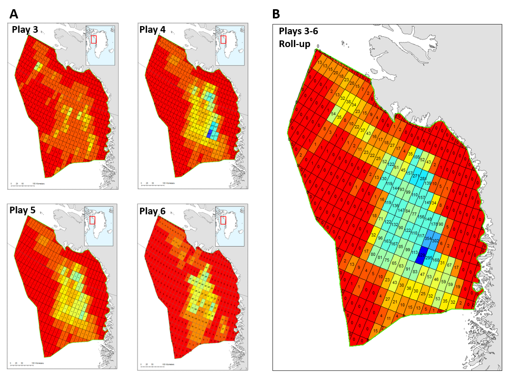
Figure 10 – Risked mean recoverable (MMBOE) per block in Assessment Unit AU2.
The total roll-up in Fig. 10B suggests that the most prospective areas are in the southern part of the Melville Bay Graben. From the roll-up per play level in Fig. 10A it is evident that the most prospective play is Play 4.
Deliverables
The results from this study including a Player® ArcGIS project and an extensive slide pack are available for the petroleum exploration industry by contacting managing director of NUNAOIL, Signe Ulfeldt Hede.
References
Acton, G., Claypool, G., Delusina, I., Dunbar, G., Evans, H., Ferretti, P., Guerin, G., Holloway, L., Ishman, S., Knutz, P.C., Krissek, L., Kulhanek, D., Insua, T.L., Lauren, J., Maloney, D., Naafs, D., Nøhr-Hansen, H., Olney, M., Richter, C., Storms, M., Woodard, S. & Wright, J., 2012. Proceedings of the Baffin Bay Scientific Coring Program – Expedition 344S, 845 p. (pdf-file – 114 MB)
Balkwill, H.R., McMillan, N.J., MacLean, B., Williams, G.L. & Srivastava, S.P. 1990: Geology of the Labrador Shelf, Baffin Bay, and Davis Strait. In: Keen, M.J., and Williams, G.L. (eds): Geology of the continental margin of eastern Canada: Geological Survey of Canada, Geology of Canada, v. 2, p. 293–348. doi.org/10.1130/DNAG-GNA-I1
Bojesen-Koefoed, J.A., 2011: West Greenland petroleum systems – an overview of source rocks and oil seepages and their implications for offshore petroleum exploration. Danmarks og Grønlands Geologiske Undersøgelse Rapport 2011/42, 49 pp.
Bojesen-Koefoed, J.A., Christiansen, F.G., Nytoft, H.P. & Pedersen, A.K. 1999: Oil seepage onshore West Greenland: evidence of multiple source rocks and oil mixing. In: Fleet, A.J. & Boldy, S.A.R. (eds): Petroleum geology of Northwest Europe: Proceedings of the 5th conference, 305–314. London: Geological Society. doi.org/10.1144/0050305
Chalmers, J.A. & Pulvertaft, T.C.R. 2001: Development of the continental margins of the Labrador Sea: a review. In: Wilson, R.C.L., Whitmarsh, R.B., Taylor, B., and Froitzheim, N. (eds): Non-volcanic rifting of continental margins: a comparison of evidence from land and sea. Geological Society of London Special Publication 187, 77–105. doi.org/10.1144/GSL.SP.2001.187.01.05
Chalmers, J.A., Pulvertaft, T.C.R., Marcussen, C. & Pedersen, A.K. 1999: New insight into the structure of the Nuussuaq Basin, central West Greenland. Marine and Petroleum Geology 16, 197–224. doi.org/10.1016/S0264-8172(98)00077-4
Christiansen, F.G. 2011: Chapter 42: Greenland petroleum exploration: history, breakthroughs in understanding and future challenges. Geological Society, London, Memoirs 35, 647-661. doi.org/10.1144/M35.42
Dam, G., Larsen, M. & Sønderholm, M. 1998: Sedimentary response to mantle plumes: implications from Paleocene onshore successions, West and East Greenland. Geology 26, 207–210. doi.org/10.1130/0091-7613(1998)026<0207:SRTMPI>2.3.CO;2
Dam, G., Pedersen, G.K., Sønderholm, M., Midtgaard, H.M., Larsen, L.M., Nøhr-Hansen, H. & Pedersen, A.K. 2009: Lithostratigraphy of the Cretaceous–Paleocene Nuussuaq Group, Nuussuaq Basin, West Greenland. Geological Survey of Denmark and Greenland Bulletin 19, 171 pp. eng.geus.dk/media/12179/nr19_p001-171.pdf
Fowler, M., Stasiuk, L. & Avery, M. 2005: Potential petroleum systems in the Labrador and Baffin shelf areas offshore north eastern Canada. In: Gonzales-Vila, F.J et al. (eds): Organic Geochemistry: challenges for the 21st century (book of Abstracts, 22nd IMOG, Seville, Spain). Abstract PBS-23, 463–464. digital.csic.es/bitstream/10261/3957/2/VOL%201%20%28segunda%20version%20revisada%29.pdf
Funck, T., Jackson, H.R., Louden, K.E. & Klingelhöfer, F. 2007: Seismic study of the transform-rifted margin in Davis Strait between Baffin Island (Canada) and Greenland: What happens when a plume meets a transform. Journal of Geophysical Research 112, B04402. doi.org/10.1029/2006JB004308
Gregersen, U., Knutz, P.C., Nøhr-Hansen, H., Sheldon, E. & Hopper, J.R. 2019: Tectonostratigraphy and evolution of the West Greenland continental margin. Bulletin of the Geological Society of Denmark 67, 1–21. 2dgf.dk/publikationer/bulletin/bulletin-volume-67-2019/#1
Japsen, P., Green, P.F. & Chalmers, J.A. 2005: Separation of Paleogene and Neogene uplift on Nuussuaq, West Greenland. Journal of the Geological Society of London 162, 299–314. doi.org/10.1144/0016-764904-038
Knudsen, C., Gregersen, U., Kokfelt, T.F., Olivarius, M. & Thomsen, T.B. 2020: A mid-Cretaceous alkaline volcano in the Davis Strait. Canadian Journal of Earth Sciences 57(1), 59–86. doi.org/10.1139/cjes-2018-0307
Knutsen, S.M., Arendt, N.P., Runge, M.K, Stilling, J. & Brandt, M.P., 2012: Structural provinces offshore West Greenland and key geological variations influencing play assessment. First Break 30, 43-55. doi.org/10.3997/1365-2397.2012021
Moore, T.E. & Gautier, D.L. (eds) 2017: The 2008 Circum-Arctic Resource Appraisal. U.S. Geological Survey Professional Paper 1824. https://doi.org/10.3133/pp1824.
Nielsen, T., Andersen, C., Knutz, P.C. & Kuijpers, A. 2011: The Middle Miocene to recent Davis Strait Drift Complex: implications for Arctic-Atlantic water exchange. Geo-Marine Letters 31, 419-426. doi.org/10.1007/s00367-011-0245-z
Núñez-Betulu, L. K., 1993. Rock-Eval/TOC pyrolysis data from the Kanguk Formation (Upper Cretaceous), Axel Heiberg and Ellesmere Islands, Canadian Arctic. Geological Survey of Canada Open File 2727, 30pp. doi.org/10.4095/192434
Oakey, G. N. & Chalmers, J.A. 2012: A new model for the Paleogene motion of Greenland relative to North America: Plate reconstructions of the Davis Strait and Nares Strait regions between Canada and Greenland. Journal of Geophysical Research 117, B10401. doi.org/10.1029/2011JB008942
Pedersen, A.K., Larsen, L.M., Pedersen, G.K. 2017: Lithostratigraphy, geology and geochemistry of the volcanic rocks of the Vaigat Formation on Disko and Nuussuaq, Paleocene of West Greenland. Geological Survey of Denmark and Greenland Bulletin 39, 247 pp. eng.geus.dk/media/19979/nr40_p001-239.pdf
Pedersen, A.K., Larsen, L.M. & Pedersen, G.K. 2017: Lithostratigraphy, geology and geochemistry of the volcanic rocks of the Maligât Formation and associated intrusions on Disko and Nuussuaq, Paleocene of West Greenland. Geological Survey of Denmark and Greenland Bulletin 40, 239 pp. eng.geus.dk/media/19979/nr40_p001-239.pdf
Schenk, C.J., 2011: Chapter 41. Geology and petroleum potential of the West Greenland−East Canada Province. In: Spencer, A.M. et al.: Arctic petroleum geology. Geological Society, London, Memoirs 35, 627-645. doi.org/: 10.1144/M35.41