Greenland Resource Assessment, North-East Greenland
(Assessment Unit 4)
Executive Summary
A play-based resource assessment of conventional hydrocarbons has been performed for the offshore areas of North-East Greenland (Assessment Unit 4, AU4) which is part of the major rift complex formed during the opening of the North Atlantic. Five post-Triassic play levels have been fully assessed in the offshore prospective area covering 1,975,000 km2. The pre-Jurassic plays (Plays 8–12) are all very deeply buried, and any internal source rocks are therefore overmature except very locally in areas around structural highs. Therefore, only identified prospectivity is considered in areas with relatively low total risk (northern Danmarkshavn Ridge).
The known prospectivity includes 308 leads from ten play levels (Devonian ‒ Eocene) with mean risked recoverable volumes of ~4,000 MMBOE. The undiscovered resources have an estimated mean of ~2,700 MMBOE risked recoverable conventional hydrocarbons. Thus, the total prospectivity has mean risked recoverable volumes of ~6,700 MMBOE resulting in an average area yield of ~3 MB/1000 km2 (risked). The unrisked Pmean volumes for the leads of the five evaluated play levels range from <1 to 1500 MMBOE with a mean of 115 MMBOE. The main prospectivity is found in the region around the Danmarkshavn Ridge, where earlier exploration efforts also were focused, however, without any exploration drilling taking place. The geologic probabilities for reservoir quality, reservoir effectiveness, seal effectiveness, trap presence and charge for AU4 were determined based on careful play mapping constructing a series of numeric CRS (Common Risk Segment) maps and CCRS (Composite Common Risk Segment) maps of the evaluated plays in the assessment area. In this manner, the probabilities are consistently applied throughout the area for both the known and unknown prospectivity. The assessment results presented are based on all available data collected and interpreted by the industry, GEUS, NUNAOIL and the Government of Greenland and reflect the state of geologic knowledge of the offshore and onshore areas of North-East Greenland at the time of study. Any future drilling and evaluation of the petroleum systems and plays based on new data within this area will add to the geologic knowledge and will therefore lead to a refinement of these assessment results. The assessment was carried out using the Player® GIS software provided by GIS-pax. The methodology and results of the assessment have been quality controlled by the Norwegian Petroleum Directorate and GIS-pax. The results of this study are reported in an extensive ArcGIS project supported by a comprehensive slide package which includes 12 presentations, reflecting the workflow of the project, including:
- Introduction
- Database
- Offshore Structural Elements
- Seismic Framework
- Seismic-Stratigraphic Framework
- Offshore Tectonic Development
- Petroleum Systems
- Learnings from Norway
- Plays Analysis
- Lead Overview
- Input Parameters
- Yet-to-Find Analysis
The Player and ArcGIS projects together with the slide pack are available for the petroleum exploration industry at no cost and can be downloaded from the project website, www.greenland-resource-assessment.gl.
Introduction
The AU4 Resource Assessment (offshore North-East Greenland and eastern North Greenland) is the fourth of seven assessments of the “Whole-of-Greenland Petroleum Resource Assessment Project” covering the entire Greenland continental shelf and adjacent onshore basins (Fig. 1). The aim of the project is to provide an estimate of a quantitative, play-based Yet-to-Find potential of conventional hydrocarbons on the Greenland continental shelf. The project was originally initiated to help the Greenland Authorities and politicians in strategic decision making and in planning of future natural resource administration. In addition, it should identify potential needs for further geological and geophysical investigations.
The project is mainly sponsored by NUNAOIL and is carried out as a collaboration between GEUS, NUNAOIL and the Government of Greenland hosted by GEUS. The work is based on all available existing data provided by the industry, GEUS, NUNAOIL and the Greenland Government. Furthermore, it includes a regional basin modelling study carried out in-house at GEUS. The results are reported as the work on the individual assessment units are finalized.
A hydrocarbon resource assessment of the Greenland continental shelf north of the Arctic Circle has previously been performed as part of the U.S. Geological Survey (USGS) Circum-Arctic Resource Program ( Gautier 2017). In this study resources in the order of 31,000 MMBOE risked recoverable were reported from the offshore East Greenland Rift Basins (mainly AU4) which is considerably higher than the present assessment. However, the USGS assessment was carried out before the recent exploration activities that resulted in a significant re-evaluation of the subsurface geology. Furthermore, the USGS assessment also used a probabilistic approach heavily relying on analogue modelling comparing the Arctic assessment units with similar but geologically better understood and better calibrated petroleum provinces elsewhere in the world. This study therefore only provided a broad overview of the possible resource potential within the assessment units of the study.
Database
The database for AU4 includes extensive 2D seismic (> 80,000 km) and gravity surveys, eleven offshore and four onshore stratigraphic wells drilled providing information on Permian to Neogene plays (Figs 2, 3). Numerous scientific publications and industry reports with data are available. Excellent outcrop analogues occur in the onshore Wandel Sea Basin and on Store Koldewey and the extensive amount of data from the Norwegian Barents Shelf has also been used as analogues where appropriate.
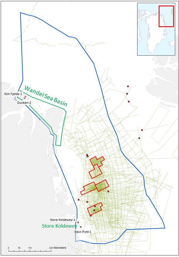
Figure 2: Seismic database (green lines) of AU4. Red dots are stratigraphic boreholes.
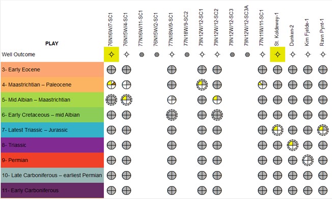
Figure 3: Well evaluation summaries for the 10 stratigraphic boreholes drilled on- and offshore AU4.
Exploration History
Exploration efforts in East Greenland have been carried out intermittently in the period between 1989 and 2014.
- In 1989, the KANUMAS-group (Kalaallit Nunaat Marine Seismic Project) – consisting of BP, Chevron, Exxon, JNOC, Shell, Statoil and NUNAOIL – was awarded a prospecting licence with special preferential rights in Baffin Bay and offshore North-East and East Greenland. Roughly 5600 km of 2D seismic data were acquired offshore North-East Greenland during 1991–1995 as part of the Kanumas project.
- In 2006–2007 Norsk Hydro acquired around 2000 km additional seismic data.
- In 2008, eleven shallow cores were drilled on the shelf with StatoilHydro as operator on behalf of the Kanumas consortium.
- Between 2008 and 2011, TGS and Ion acquired more than 20,000 km 2D seismic data ahead of the announced opening up for subsurface exploration licensing in 2012.
- Between 2011 and 2016 VBPR and TGS collected seabed samples through gravity coring and dredging.
- Following licensing rounds in 2012 and 2013, five licences offshore North-East Greenland were granted to BP, Chevron, Shell, Statoil and NUNAOIL, japansk firma? (the KANUMAS partners) and ConocoPhilips, Eni and DONG E&P (Fig. 2). During this period, more than 32,000 kilometres additional 2D seismic data were acquired (Fig. 2).
As a result of the collapse of the oil price in 2014, all licences were relinquished in 2018 and exploration activities have ceased.
Seismic-Stratigraphic Interpretation
The regional seismic stratigraphic interpretation is based on a GEUS and NUNAOIL in-house interpretation. Twelve super-regional to sub-regional seismic stratigraphic key horizons in addition to the seabed have been picked within AU4 (Fyhn & Hopper 2021; Fyhn et al. 2021). Only the five youngest horizons benefit from direct age control from shallow coring and seabed sampling. In addition, inferred ages are based on regional correlations with onshore and conjugate margin stratigraphy. This especially, but not solely, applies to the sub/pre-mid-Cretaceous horizons.
The regional seismic stratigraphic key horizons that have been mapped in AU4 are (Figs 3, 4): A: Seabed;
B: Mid-Miocene; C: Near base mid-Eocene; D: Near-base Eocene; E: Intra-Maastrichtian; F: Mid-Cretaceous, G: Near-top Jurassic (intra Volgian) H: Top salt (Lower Permian), and I: Base salt (intra-Upper Carboniferous). In addition,J: Basement, K: Near-base Carboniferous, and L: Near-base Jurassic have been picked locally. The near-base Triassic horizon (M) was constructed midways between the near-base Jurassic and the top salt horizons for the sole purpose of basin modelling and evaluations of reservoir effectiveness. In areas where horizons could not be traced due to great burial depth or the presence of overlying Palaeogene intrusions or basalts hampering the identification of deeper stratigraphy, horizon F, G, H, K and the near-base Triassic (M) have been constructed taking the structural configuration into consideration to minimize errors. These are purely hypothetical horizons with a very large degree of uncertainty.
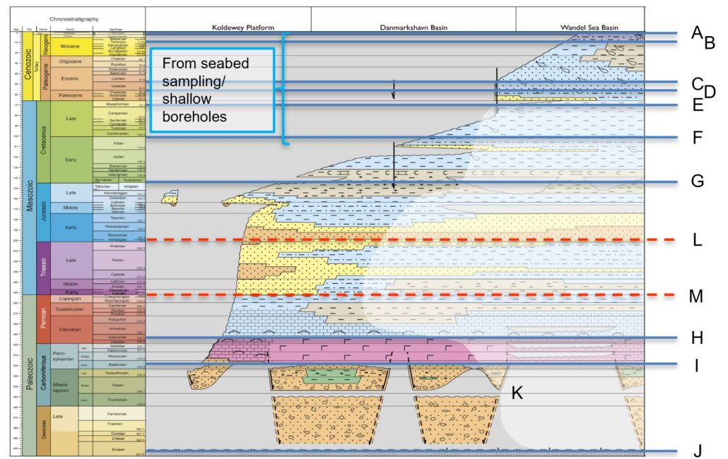
Figure 4: Stratigraphy and interpreted and constructed seismic horizons used in AU4.
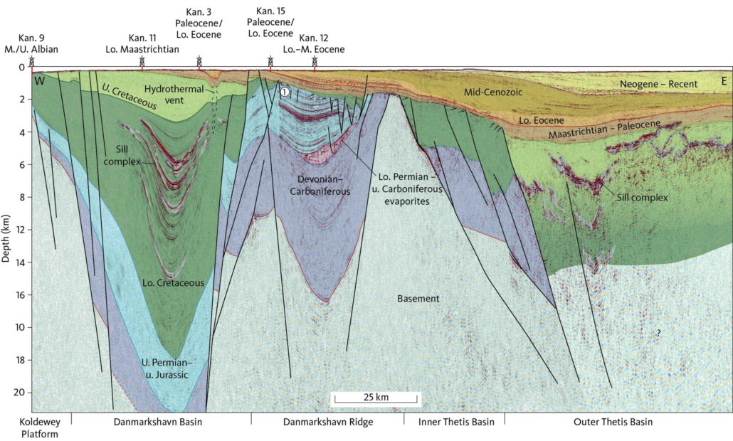
Figure 5: Seismic sections with well-information projected onto the line. Location of line shown on Fig. 6. From Fyhn et al. 2021.
Tectonostratigraphic Evolution
The tectonic evolution of the Greenland Sea – Fram Strait region is complex involving multiple phases of rifting/transtension related to the separation and eventual break-up of Greenland and Eurasia as well as intervening phases of tectonic quiescence and phases of compression/transpression in the north (e.g. Hamann et al. 2005; Rowan & Jarvie 2020, Fyhn et al. 2021; Fyhn & Hopper 2021). Furthermore, the southern part of AU4 is strongly affected by the North Atlantic Mantle Plume, resulting in Paleocene and early Eocene intrusive activity and also flood magmatism along its southern borders. Intrusions partly hamper deep seismic imaging and restrict the level of detail to which structural and stratigraphic interpretation is possible with the existing dataset. The same goes for the basalt covering a small fraction of AU4 in the south (Fig. 6).
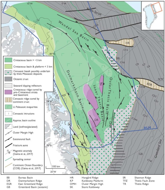
Figure 6: Structural elements map of the North-East and eastern North Greenland margin (AU4). Location of seismic section shown in Figure 5 indicated by red line. Modified after Fyhn et al. (2021).
The structural outline in the southern and central part of AU4 is well constrained due to the fairly dense seismic data coverage. The structural outline is more loosely constrained on the outer margin to the east due to the open seismic grid over this area. The structural outline of the northern part of AU4 is poorly constrained due to the scarcity of good seismic data in this vast area. AU4 comprises three sedimentary basins: (1) the Danmarkshavn Basin in the west, (2) the Thetis Basin in the east, and (3) the Wandel Sea Basin in the north (Fig. 6). The Koldewey Platform borders the Danmarkshavn Basin to the west and the Danmarkshavn Ridge separates the Danmarkshavn Basin from the Thetis Basin. The Danmarkshavn Ridge plunges towards the north, but major tilted fault blocks are located along its northward continuation. The Wandel Sea Basin stretches from onshore eastern North Greenland and south-eastwards into the offshore realm. The boundary between the Wandel Sea Basin and the Danmarkshavn/Thetis basins is not firmly established. The Danmarkshavn/Thetis Basins formed in response to rifting whereas the Wandel Sea Basin is also affected by lateral shearing associated with the transform motions taking place between the Barents Sea margin and North Greenland.
The Thetis Basin is subdivided into a super deep and intruded outer basin and a shallower and less intruded inner basin (Fig. 6). The Thetis Ridge denotes the faulted boundary between the inner and outer Thetis Basin to the north, while a fault zone denotes the boundary farther south. Earliest Eocene and younger oceanic crust flank the Thetis Basin to the east (Fig. 6).
Six major tectonostratigraphic phases have been recognized offshore North-East Greenland: (1) Devonian-Carboniferous, (2) latest Carboniferous to Early Permian, (3) Late Permian to Jurassic, (4) latest Jurassic to Paleocene, (5) Eocene to Miocene, and (6) middle Miocene to Recent (Fig. 7; Fyhn & Hopper 2021). Some of the phases can be further subdivided based on the tectonic development. Only the Albian and younger stratigraphy is documented in wells and seabed samples. The older stratigraphy and tectonic history are dated based on comparisons with the conjugate Norwegian margin as well as the exposed onshore basins in North-East Greenland.
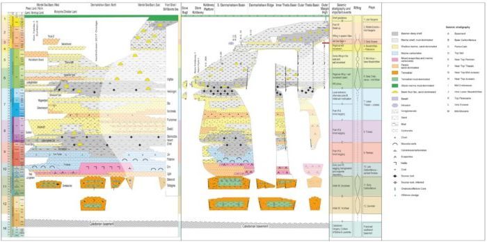
Figure 7: Tectonostratigraphic evolution of the North-East Greenland shelf and onshore areas.
Basement underlying AU4 is most likely composed by Caledonian (Silurian to Devonian) high-grade metamorphic rocks similar to onshore North-East Greenland and onshore mid- and northern Norway (Gilotti et al. 2008). Rifting and basin development probably commenced during the Middle Devonian, simultaneous to the formation of the oldest post-Caledonian sediments in North-East Greenland, in mid-Norway and on Bjørnøya located on the conjugate margin to AU4. However, the relation between latest Devonian ultra-high-grade metamorphism recorded locally along the western flank of the Koldewey Platform and the onset of rifting and deposition is unknown. Hence, the oldest sediments could potentially be as young as the Carboniferous – at least locally. Large grabens and half-grabens filled with as much as nine kilometres of sediment formed during this Devonian(?) to Early Carboniferous rift phase. Internal intra- to syn-rift unconformities and changes in fault orientations during this rift phase suggest changes in tectonic regime during this period. One of these changes has been used as a potential marker for the near-base Carboniferous interpreted sub-regionally in AU4 due to comparable changes in structural style taking place onshore North-East Greenland of roughly this age.
The Devonian(?) to Lower Carboniferous syn-rift succession is overlain by evaporites and related deposits extensively mobilised into salt diapirs and pillows and deposited during and after the final stage of Palaeozoic extension. Comparable uppermost Carboniferous to Lower Permian evaporites are known on the conjugate western Barents Sea margin and from onshore North Greenland where they occur together with carbonates and cherts (Stemmerik 2000).
The evaporites are overlain by a typically few kilometres thick interval characterised by rather uniform thickness and parallel reflectors over much of AU4. The lower half of this succession is characterised by the most uniform thicknesses and internally parallel reflectors, whereas the upper half locally displays some variation in thickness associated with faulting and incipient salt movement. The two parts are divided by a strong “soft-kick” reflector or a set of closely spaced reflectors that may indicate the presence of e.g. coals. The interval is therefore tentatively correlated with the uppermost Triassic to lowermost Jurassic coaly Åre Formation on the conjugate Norwegian Sea margin and the lowermost Jurassic source-prone Rhætelv Formation in Central East Greenland. These “soft-kick” reflectors are therefore tentatively suggested to represent the near-base Jurassic. The underlying succession is sandwiched between the uppermost Carboniferous to Lower Permian evaporites and the near-base Jurassic and is thus regarded to be of Late Permian and Triassic age. Although it is not possible to distinguish between Triassic and Upper Permian strata on a regional basis in AU4 the period appears to have been characterised by tectonic quiescence and gradual subsidence/deposition comparable to what is known from the Barents Sea but contrasting the Early Triassic active rifting occurring farther south onshore North-East and central East Greenland and offshore the mid-Norwegian margin (Henstra et al. 2017; Bunkholdt et al. 2021). It is therefore suggested that this period is characterised by marine carbonate deposition in AU4 during the Late Permian and deltaic to deep-marine conditions in the Triassic.
The overlying Jurassic succession displays signs of local, moderate normal faulting, which may be equivalent to especially the Middle and Late Jurassic faulting documented onshore North-East Greenland and on the conjugate Norwegian margin. Both onshore North-East and North Greenland and offshore Norway, the Jurassic includes widespread sandy shallow marine intervals (Surlyk 2003; Bunkholdt et al. 2021), and there are no indications for this not being the case within AU4 also.
Onset of strong rifting and rift basin development is shown by the development of a very distinct angular unconformity over structural highs that is conformable with over- and underlying strata in the basins. In this respect the surface closely resembles, and is interpreted as, the super-regional, intra-Volgian/Berriasian unconformity documented onshore North-East Greenland and offshore Norway all the way from the Barents Sea to the North Sea (Fyhn et al. 2021). The rift onset unconformity floors an uppermost Jurassic to mid-Cretaceous rift-succession exceeding ten kilometres in thickness in the southern and central parts of the Danmarkshavn Basin and is also very thickly developed in the outer Thetis Basin. In the Inner Thetis Basin and in the northern Danmarkshavn Basin, the unit is considerably thinner developed. The succession lacks over much of the Danmarkshavn Ridge that formed in response to latest Jurassic through Cretaceous rift-shoulder uplift associated with downfaulting towards the Thetis Basin (Fyhn et al., 2021).
From the mid-Cretaceous, rifting virtually ceased in the southern and central Danmarkshavn Basin. Instead rifting continued during the Late Cretaceous in the outer Thetis Basin and in the northern Danmarkshavn Basin, where an up to 2–3 km thick Upper Cretaceous post-rift succession was formed, and probably also in the Wandel Sea Basin (Fyhn et al. 2021).
During the Maastrichtian, a second shift in rifting occurred during which rifting stepped farther eastwards towards the future line of break-up whereby large Maastrichtian to earliest Eocene fault structures formed on the outermost margin in AU4 which was also affected by magmatism (Fyhn et al. 2021). Initially, presumably during the early and/or middle Paleocene, subaqueous lavas were extruded on the outer margin in the south (Hovikoski et al. 2021). Subsequently subaerial lavas were extruded during mostly earliest Eocene time along the southern edge of AU4 and the line of continental break-up that also was established at this point in time. The flood basalts grade into seaward dipping reflector sequences along the southern part of the Thetis Basin margin. Basaltic magma intruded Cretaceous and older strata in the Thetis and the southern and central Danmarkshavn Basin generally around the Paleocene-Eocene transition. Apart from resulting in hydrothermal venting above the intrusions (Reynolds et al. 2017), the accumulated thickness of the intrusions also resulted in uplift and erosion of the south-western Danmarkshavn Basin (Hovikoski et al. 2021). On a more regional basis, the deposition of sub-aerial basalts along the East and North-East Greenland margin diverted the East Greenland drainage pattern towards AU4 in the north causing massive amounts of most likely sandy deposits to be shed into the southern Thetis Basin associated with east-north-eastward progradation of the lower and middle Eocene offlap break (Hovikoski et al. 2021).
During the remainder of the Eocene, the Oligocene and the early Miocene, a high shelf slope developed which prograded eastwards in response to uplift end erosion of the East and North-East Greenland inner continental margin. Farther north rifting and transtension took place in the outer parts of the Wandel Sea Basin until the final break-up between northern Norway and North-East Greenland was completed presumably during the Miocene (Engen et al. 2008).
Around the time of the final break-up major glaciations started to affect the North-East Greenland margin. This resulted in repeated shelf glaciations of much of AU4 and the formation of large trough mouth fans that in the Thetis Basin build out more than 100 km since the middle Miocene glacial onset. At the same time, uplift and erosion intensified over the western part of AU4.
Plays and Play Elements
Based on seismic interpretation, well and outcrop data, 12 plays have been established on the North-East Greenland continental shelf (Fig. 7). However, only Plays 3–7 are included in the Yet-to-Find evaluation as Plays 1 and 2 are not considered to have any exploration potential in the area and Plays 8–12 (pre-Jurassic) are both poorly known and very deeply buried resulting in only very local and limited exploration potential along the Danmarkshavn Ridge. Six source rock intervals have been documented on the North-East and East Greenland continental margin and reservoir rocks are present virtually at all stratigraphic levels. High-quality seals are well documented in Albian deep marine shales (Fig. 7; Chevron 2016).
Petroleum Systems
Onshore indications of viable petroleum systems in AU4 include three cases of oil-staining/seepage recorded in two fully cored boreholes in eastern Peary Land and in outcrops in a fracture zone in Germania Land (Christiansen & Bojesen-Koefoed, 2021). The Kim Fjelde-1 borehole in Peary Land (Fig. 2) shows petroleum stains in the Upper Permian Midnatfjeld Formation. The stains occur in a marine mudstone succession, which is essentially without petroleum source potential, but based on geochemical characteristics, the stains are intraformational, and suggest that intervals within the Upper Permian succession possess petroleum generation potential but have not been detected by the otherwise dense sampling and analysis of the core. Similarly, the Dunken-2 borehole in Peary Land (Fig. 2) includes oil stains in the Middle Triassic Dunken Formation. The stains occur in a marine mudstone succession, which is essentially without petroleum source potential, but based on geochemical characteristics, the stains are intraformational, and suggest that intervals within the Triassic succession possess petroleum generation potential but have not been detected by the otherwise dense sampling and analysis of the core. A mineralised fracture zone in gneissic rocks in Germania Land shows the presence of oil droplets in cavities in the quartz cement that have precipitated in the fracture zone. The oil suggests an Upper Jurassic age of the source (Bojesen-Koefoed et al. 2009). However, the exact source of the oil remains elusive since the region is barren of sedimentary rocks. Long-distance migration from the offshore areas may thus pose a possibility. In the offshore area seismic data frequently show DHIs of different kinds such as cross-cutting events, gas chimneys and amplitude anomalies, the latter often being observed above gas chimneys.
Potential petroleum source rocks considered for AU4 are listed in Table 1 and discussed below. Devonian source rocks include equivalents of the highly prolific Upper Devonian lacustrine shales of the Obrutschew Bjerg Formation, known from the Ymer Ø – Gauss Halvø region south of AU4 (Christiansen et al., 1990a, 1992; Olsen 1993; Olsen & Larsen 1993). Such deposits are not known from AU4 but are presumably present in parts of the offshore areas. The Carboniferous is represented by a hypothetical unit, defined as an estimated intermediate between the Lower Carboniferous coaly deposits of the Sortebakker Formation of Holm Land, North-East Greenland, and the corresponding Tettegras Formation of the Barents Shelf (van Koeverden et al., 2010, 2011), combined with the Upper Carboniferous lacustrine deposits of the Traill Ø Group (Christiansen et al. 1990a, 1992; Piasecki et al. 1990; Stemmerik et al. 1990, 1993). The Sortebakker Formation is the only Carboniferous organic-rich unit documented in AU4.
Based on available data different characteristics of Upper Permian source rocks are used in the northern and southern areas of AU4. In northern areas data are scanty, but the Gotha discovery on the Barents shelf was charged from the Upper Permian Ørret Formation and petroleum staining is known from the Midnatfjeld Formation in Peary Land, pointing to the presence of petroleum potential (Lerch 2016; Pedersen et al. 2005; Stemmerik & Worsley, 2005; Ohm et al., 2008; J.H. Pedersen, Lundin Energy Norway, pers. comm. 2020). Hence, in the northern parts of AU4, the characteristics of Upper Permian source rocks are based primarily on data from the Ørret Formation near the Gotha discovery. In the southern parts of AU4, the characteristics of Upper Permian source rocks are based on the well-documented Ravnefjeld Formation (Christiansen et al. 1990b, 1993; Piasecki & Stemmerik 1991).
Triassic petroleum source rocks are only expected in the northern part of AU4. Rich oil-prone mid-Triassic source rocks are known from the Botneheia Formation of Svalbard and from the Steinkobbe Formation of the Barents Sea (Abay et al. 2017; Lundschien et al. 2014; Mørk et al. 1999 and references therein). Recently, corresponding units have been documented from Peary Land and Kilen and palaeogeographic reconstructions suggest widespread deposition of marine petroleum source rocks in the region during the Ladinian – Carnian (Alsen et al. 2017; Bjerager et al. 2019).
Upper Jurassic – Lower Cretaceous petroleum source rocks, equivalents of the principal source rocks of the greater North Sea Petroleum province and the Barents Sea, are widely distributed and exposed in North-East Greenland, albeit in the area defined as AU4 only small outcrops representing marginal facies are exposed on Store Koldewey and in Kilen. The presence of prolific basinal facies deposits in the offshore areas of AU4 can justly be assumed, and their properties estimated from well-studied successions onshore North-East Greenland (Requejo et al. 1989, Christiansen et al. 1992, Surlyk & Noe-Nygaard 2001; Surlyk 2003; Strogen et al. 2005; Bojesen-Koefoed et al. 2018; Ineson & Bojesen-Koefoed 2018).
Based on regional considerations the presence of a Cenomanian–Turonian source rock may be speculated upon. Data from Ellesmere Island and Baffin Bay show that this interval can be highly prolific (Nøhr-Hansen et al. 2021 and references therein). Furthermore, petroleum accumulations sourced from mid-Cretaceous marine source rocks have been documented on the mid-Norway shelf (Matapour & Karlsen 2018) and from the Nanok-1 borehole at Hold with Hope in central East Greenland (Bojesen-Koefoed et al. 2020). This interval has therefore been included as an option in the basin modelling study and in the charge risking.
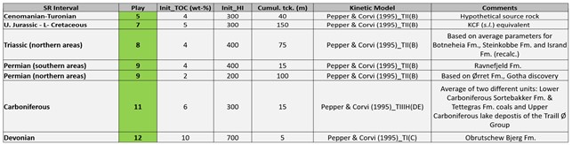
Table 1 – Source rock intervals identified for Assessment Unit 4 showing values selected for the basin modelling study.
Basin Modelling
In the conducted regional basin modelling study, the potential petroleum source rocks data listed in Table 1 have been used as source rock characteristics. Important input considerations such as amount of erosion, has been summed up to two erosion/uplift events: one during the Early Cretaceous centered around the Danmarkshavn Ridge (locally with up to ˃ 5-6 km of uplift) and the most recent during the Late Cenozoic with more than 2 km along the Koldewey Platform. The amount of uplift is based on measured vitrinite reflection data of seabed samples and shallow core boreholes and interpretation of seismic data. The lack of deep offshore wells and scattered maturity data derived from shallow and gravity cores across the shelf impedes calibration of the maturity model. An averaged heat flow history with minor rifting peak (55 mW/m2) and a present-day heat flow of 50 mW/m2 was used.
Basin modelling indicates that the two uplift phases have profound effects on the source rock maturation history. The modelling suggests that the Upper Jurassic source rock (Play 7) is immature to early mature on the Koldewey Platform and on the Danmarkshavn Ridge (depending on timing and extent of the Early Cretaceous uplift event), and late mature to overmature in the Danmarkshavn and Thetis Basins except from local smaller areas. The four deeper situated source rocks become gradually more overmature as the source rock intervals become older and thus deeper buried.
Furthermore, the maturity modelling suggests that all pre-mid-Cretaceous source rock intervals in the southern part of AU4 are generally late to overmature but may have reached level of thermal maturity sufficient for petroleum generation on the Koldewey Platform, local areas in the Danmarkshavn Basin and along the Danmarkshavn Ridge. In the northern part of AU4, the Upper Jurassic source rock (Play 7) and especially the Triassic and Permian source rocks (Plays 8 and 9) may have reached a level of maturity sufficient for gas generation. Generally, the source rock intervals are overmature in the deeply buried sub-basins in most of the Danmarkshavn Basin and the Inner and Outer Thetis Basin. The hypothetical Cenomanian–Turonian source rock would – if present – be thermally mature in the eastern part of AU4 (Thetis Basin).
The modelling of generation and migration suggests that both vertical and lateral migration into reservoirs with closures/accumulations from the six (with the hypothetical Cenomanian–Turonian source rock) potential source rock intervals is possible. Thus, the most prospective areas are found in areas north of and along the west side of the Danmarkshavn Ridge.
However, an important element of the charge modelling is the large amount of local uplift – especially the Late Cenozoic uplift of up to approximately 2000 m on the Koldewey Platform and the Early Cretaceous uplift of more than 5000 m on the Danmarkshavn Ridge, where the hydrocarbons charge will be switched off. Likewise, local timing risk issues must be addressed to fully assess the prospectivity of specific areas.
Assessment Process
The assessment process for the resource evaluation of AU4 is summarised in the “Yet-To-Find Triangle” shown in Figure 8. Basin evaluation is the basic activity describing the structural and stratigraphic framework leading into construction of Gross Depositional Environment (GDE) maps and identification of source rocks, reservoirs and regional seals that form the basis for definition of the plays. IES PetroMod v16.2 has been used to compile and setup a 3D basin reference model to assess maturity and possible migration for expected source rock intervals.
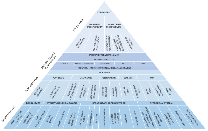
Figure 8: Resource evaluation workflow used in the Greenland Resource Assessment.
The results from the Basin Evaluation feed into the Play Analysis. In this analysis, numeric Common Risk Segment (CRS) and Composite Common Risk Segment (CCRS) maps have been constructed based on all available geological and geophysical data and exploration history data.
The following play risk elements have been assessed: Reservoir Presence (based on GDE maps), Reservoir Effectiveness (based on depth to interval maps), Seal Effectiveness (based on overburden thickness maps corrected for uplift) and Charge-Migration (based on source presence and maturity maps and drainage maps), and Trap Presence (based on possibility to obtain high-quality seismic data).
A single charge scenario is applied for all pre-Upper Cretaceous plays (Plays 6–12) in AU4. For the post-Triassic plays the documented uppermost Jurassic (Kimmeridgian) to lowermost Cretaceous (Oxfordian–Ryazanian) source rock has been used for Plays 7–3 with an additional, inferred Cenomanian–Turonian source rock for Plays 5–3 in the charge evaluations. A detailed description of the charge evaluation process is found in the PowerPoint presentations available on the data portal.
Volumes for leads mapped by the industry, GEUS and NUNAOIL have been integrated into the play evaluation and the identified prospectivity has been calculated. For the volume calculations of individual leads the oil-water contact has been picked halfway between the top of the structure and spill point, since source rock quality analysis does not support fill-to-spill scenarios. Furthermore, maximum possible oil-column is set to 500 m based on data from the Norwegian shelf.
Although the Oxfordian–Ryazanian source rock interval is gas-prone or overmature in large areas, gas risk has not been assessed and all volumes are in MMBOE. For analysis on volumetrics of individual phases, more detailed analysis and mapping have to be carried out.
The Yet-to-Find analysis is based on a feature (lead) density calculation approach for each of the identified play intervals. In Assessment Unit 4 estimates of Analog Feature Density for each play is based on observed feature densities in areas with relatively high seismic density where an almost complete mapping of possible 4-way leads is anticipated. Based on these estimates the unidentified prospectivity has been calculated for the AU4.
Resource Assessment
The resource assessment provides an estimate of the play-based Yet-to-Find potential of conventional hydrocarbons. The assessment includes Plays 3, 4, 5, 6 and 7 (Fig. 7). Plays 1 and 2 are located at very shallow depths below seabed and are therefore not considered prospective. The pre-Jurassic plays (Plays 8–12) are all very deep-seated in most areas, resulting in very high Total Risk outside the northern Danmarkshavn Ridge area. These are therefore not considered further in the Yet-to-Find assessment.
Known Prospectivity
The first step in the Yet-to-Find Assessment was to make Gross-Rock Volumes for the leads mapped by the industry, GEUS and NUNAOIL in AU4. A total of 308 leads have been evaluated in Assessment Unit 4 (Fig. 9). Gross-Rock Volume calculations were made in Player® based on area-depth pairs from the top of structure to spill-point. Area-depth pairs were derived from either mapping of the structures in Petrel or digitizing of closure and contour lines in ArcGIS from company reports. In case of overlapping leads, leads mapped by GEUS and NUNAOIL were chosen. For identified structures without area/depth pairs (unevaluated leads), area yield values have been applied.
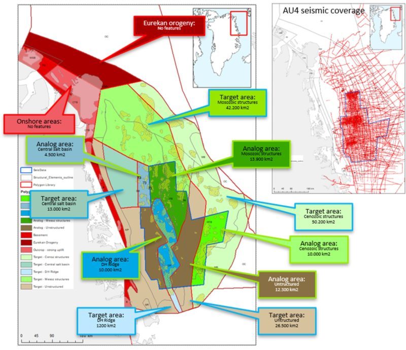
Figure 9: Identified leads in AU4. Analog and target areas (defined based on seismic coverage) for the Yet-to-Find calculations are also shown.
For the hydrocarbon volume calculations, the following input parameters have been considered for all leads: 1) Porosity, 2) Gross and net sand thicknesses and Net-to-Gross Ratio, 3) Oil Saturation, 4) Oil formation volume factor (Bo), 5) Recovery Factor (RF), and 6) Gas expansion factor (E). These input parameters are based on well data, information about water depths, interpretation of petrophysical well-logs, saturation curves, and information from publications etc.
The known prospectivity appears from integrating the calculated identified lead volumes (see section above) with the CCRS maps providing the risked volumes for the leads.
Unidentified Prospectivity
As mentioned above, the unidentified prospectivity analysis is based on the observed Feature Densities (FD) in the areas with good seismic coverage. Onshore areas and areas heavily affected by the Eurekan Orogeny or with oceanic crust are not included as Target Areas (Fig. 8).
The “Future Target Area FD (per play)” = “Analog Area (FD)” ÷ “Identified Target Area FD”.
The unidentified prospectivity is the “Future Target Area FD (per play)” × “Mean volume per Feature MMBOE)”.
A summary of the results by Play Interval (Identified Prospectivity) and results by Play Interval (Unidentified Prospectivity) is shown in Table 2.
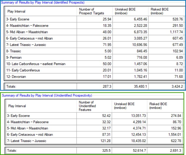
Table 2: Summaries of Identified and Unidentified Prospectivity in Assessment Unit 4. The Total Risked Recoverable (Mean Case) is 6,100 MMBOE if based on all individual leads
However, the southern Danmarkshavn Ridge may be regarded as one big ‘mega-lead’ instead of several smaller leads at different levels, and in this case, this will add 575 MMBOE (risked) to the known prospectivity, resulting in a total risked prospectivity of 6,700 MMBOE (for details, see documentation on Yet-to-Find Assessment).
Portfolio Analysis
Although Total Risk appears to be acceptable for large parts of AU4 (Fig. 10) it should be noticed that these risks rely on the possibility to acquire high-quality seismic data in the entire region, i.e. that trap risk will be low. With the ice conditions encountered offshore North-East Greenland this is not possible at present. Furthermore, phase risk (gas) has not been dealt with here as well as local timing issues which must be addressed to fully assess the prospectivity of specific areas.
At present, the most prospective areas are found areas close to or covered by previous licences north of and along the western side of the Danmarkshavn Ridge (Fig. 10).
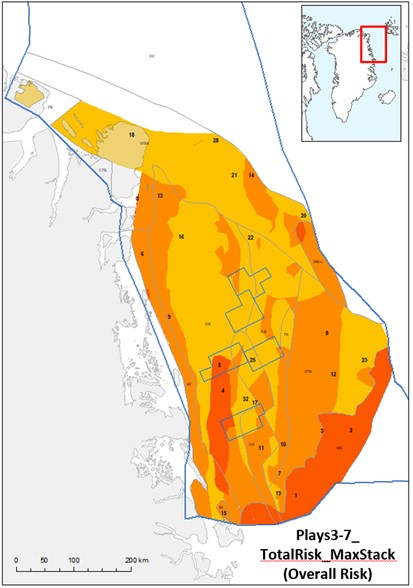
Figure 10: Maximum risk value stack for Plays 3–7 with previous licences (2013–2018) indicated.
Deliverables
The results from this study including a Player® ArcGIS project and an extensive slide pack are available for the petroleum exploration industry by contacting Thomas Varming at NUNAOIL.
References
Abay, T.B, Karlsen, D.A., Pedersen, J.H., Olaussen, S & Backer-Owe, K. 2017: Thermal maturity, hydrocarbon potential and kerogen type of some Triassic–Lower Cretaceous sediments from the SW Barents Sea and Svalbard. Petroleum Geoscience 24, 349–373. doi.org/10.1144/petgeo2017-035
Alsen, P., McRoberts, C., Svennevig, K., Bojesen-Koefoed, J., Hovikoski, J. & Piasecki, S. 2017: The Isrand Formation: a Middle Triassic Daonella-bearing, black shale unit in Kilen, North Greenland (with a note on the Triassic in Amdrup Land). Newsletters on Stratigraphy 50, 31-46. doi.org/10.1127/nos/2016/0341
Bjerager, M., Alsen, P., Hovikoski, J., Lindström, Pilgaard, A. Stemmerik, L. & Therkelsen, J. 2019: Triassic lithostratigraphy of the Wandel Sea Basin, North Greenland. Bulletin of the Geological Society of Denmark 67, 83–105. doi. org/10.37570/bgsd-2019-67-06
Bojesen-Koefoed, J.A., Alsen, P., Christiansen, F.G., Nytoft, H.P., Piasecki, S. & Stemmerik, L. 2009: Northeast Greenland petroleum systems. Danmarks og Grønlands Geologiske Undersøgelse Rapport 2009/43, 342 pp.
Bojesen-Koefoed, J.A., Bjerager, M., Nytoft, H.P., Petersen, H.I., Piasecki, S. & Pilgaard, A. 2018: Petroleum potential of the Upper Jurassic Hareelv Formation, Jameson Land, East Greenland. In: Ineson & Bojesen-Koefoed (eds) Geological Survey of Denmark and Greenland Bulletin 42, 85–113. doi.org/10.34194/geusb.v42.4314
Bojesen-Koefoed, J.A., Alsen, P., Bjerager, M., Hovikoski, J., Ineson, J., Nytoft, H.P., Nøhr-Hansen, H., Petersen, H.I., Pilgaard, A. & Vosgerau, H. 2020: A mid-Cretaceous petroleum source-rock in the North Atlantic region? Implications of the Nanok-1 fully cored borehole, Hold with Hope, North-East Greenland Marine and Petroleum Geology 117. doi.org/10.1016/j.marpetgeo.2020.104414
Bunkholt, H.S.S., Oftedal, B.T., Hansen, J.A., Løseth, H. & Kløvjan, O.S. 2021: Trøndelag Platform and Halten–Dønna Terraces composite tectono-sedimentary element, Norwegian rifted margin, Norwegian Sea. Geological Society, London, Memoirs 57. doi.org/10.1144/M57-2017-13
Chevron 2016: Seal analysis of marine mudstones and siltstones offshore NE Greenland. Unpublished company report, 34 pp (in the archives of MRA).
Christiansen, F.G. & Bojesen-Koefoed, J.A. 2021: Inventory of onshore petroleum seeps and stains in Greenland: a web-based GIS model, GEUS Bulletin 47, 20 pp. doi.org/10.34194/geusb.v47.6519
Christiansen, F.G., Olsen, H., Piasecki, S. & Stemmerik, L. 1990a: Organic geochemistry of Upper Palaeozoic lacustrine shales in the East Greenland basin. Organic Geochemistry 16, 287–294.
Christiansen, F.G., Piasecki, S. & Stemmerik, L. 1990b: Thermal maturation history of the Upper Permian succession in the Wegener Halvø area, East Greenland. Rapport Grønlands Geologiske Undersøgelse 148, 109-114. doi.org/10.34194/rapggu.v148.8129
Christiansen, F. G., Bojesen-Koefoed, J., Jensen, S. M. & Stemmerik, L. 1991: Oil seep in basement, Germania Land, North-East Greenland. Open File Series Grønlands Geologiske Undersøgelse 91/7, 29 pp.
Christiansen, F. G., Dam, G., Piasecki, S. & Stemmerik, L. 1992: A review of Upper Palaeozoic and Mesozoic source rocks from onshore East Greenland.: Generation, accumulation and production of Europe`s hydrocarbons II. In: Spencer, A. M. (ed.), Special Publication of the European Association Petroleum Geologists 2, 151–161.
Christiansen, F.G., Piasecki, S., Stemmerik, L. & Telnæs, N. 1993: Depositional environment and organic geochemistry of the Upper Permian Ravnefjeld Formation source rock in East Greenland. American Association of Petroleum Geologists Bulletin 77, 1519-1537.
Engen, Ø., Faleide, J.I. & Dyreng, T.K., 2008: Opening of the Fram Gateway: A review of plate tectonic constraints. Tectonophysics 450, 51–69. doi.org/10.1016/j.tecto.2008.01.002
Fyhn, M.B.W., Hopper, J.R., 2021. North-East Greenland Composite Tectono-Sedimentary Element. In: Drachev, S., Henriksen, E., Moore, T., Brekke, H. (eds) Arctic Sedimentary Basins. Geological Society, London, Memoirs, in press.
Fyhn, M.B.W., Hopper, J.R., Sandrin, A., Lauridsen, B.W., Heincke, B.H., Nøhr-Hansen, H., Andersen, M.S., Alsen, P., Nielsen, T., 2021: Three-phased latest Jurassic–Eocene rifting and mild mid-Cenozoic compression offshore NE Greenland. Tectonophysics 815, 228990. doi.org/10.1016/j.tecto.2021.228990
Gautier, D.L. 2017: Geology and assessment of undiscovered oil and gas resources of the East Greenland Rift Basins Province, 2008. In: Moore, T.E. & Gautier, D.L. (eds): The 2008 Circum-Arctic Resource Appraisal, Chapter K. U.S. Geological Survey Professional Paper 1824. doi.org/10.3133/pp1824K
Gilotti, J.A., Jones, K.A. & Elevold, S. 2008: Caledonian metamorphic patterns in Greenland. In: Higgins, A.K., Gilotti, J.A. & Smith, M.P. (eds.) The Greenland Caledonides: Evolution of the North-East margin of Laurantia. Geological Society of America Memoir 202, 201–225. doi.org/10.1130/2008.1202(08)
Hamann, N.E., Whittaker, R.C., Stemmerik, L., 2005: Geological development of the North-East Greenland Shelf. In: Doré, A.G., Vining, B.A. (eds) Petroleum Geology: North-West Europe and Global Perspectives–Proceedings of the 6th petroleum Geology conference, 887–902. Geological Society, London. doi.org/10.1144/0060887
Henstra, G.A., Gawthorpe, R.L., Helland-Hansen, W., Ravnås, R. & Rotevatn, A. 2017: Depositional systems in multiphase rifts: seismic case study from the Lofoten margin, Norway. Basin Research 29, 447–469. doi.org/10.1111/bre.12183
Hovikoski, J. et al. 2021: Fragmentation of Norwegian–Greenland Seaway during the Early Paleogene. Communications Earth & Environment 2, 172. doi.org/10.1038/s43247-021-00249-w
Ineson, J.R. & Bojesen-Koefoed J.A. (eds) 2018: Petroleum geology of the Upper Jurassic – Lower Cretaceous of East and North-East Greenland: Blokelv-1 borehole, Jameson Land Basin. Geological Survey of Denmark and Greenland Bulletin 42, 168 pp.
Lerch, B. 2016: Petroleum Systems of the Barents Sea. Unpublished PhD thesis, University of Oslo, 95 pp.
Lundschien, B.A., Høy, T. & Mørk, A. 2014: Triassic hydrocarbon potential in the Northern Barents Sea; integrating Svalbard and stratigraphic core data. Norwegian Petroleum Directorate Bulletin 11, 3–20. www.npd.no/global/norsk/3-publikasjoner/npd-bulletin/bulletin-11-kap/npd_bulletin_lundschien_scr.pdf
Matapour, Z. & Karlsen, D.A. 2017: Ages of Norwegian oils and bitumen based on age-specific biomarkers. Petroleum Geoscience 24(1). doi.org/10.1144/petgeo2016-119
Mørk, A., Dallmann, W. et al. 1999: Mesozoic lithostratigraphy. In: Dallmann, W.K. (ed.) Lithostratigraphic Lexicon of Svalbard: Review and Recommendations for nomenclature use. Upper Palaeozoic to Quaternary bedrock, 127–214. Norwegian Polar Institute, Tromsø, Norway. nhm2.uio.no/norges/litho/svalbard/meso_text.htm
Nøhr-Hansen, H., Pedersen, G.K., Knutz, P.K., Bojesen-Koefoed, J. A., Sliwinska, K.K., Hovikoski, J., Ineson, J.R., Kristensen, L. & Therkelsen, J. 2021: The Cretaceous succession of North-East Baffin Bay: Stratigraphy, sedimentology and petroleum potential. Marine and Petroleum Geology 133. doi.org/10.1016/j.marpetgeo.2021.105108
Ohm, S.E., Karlsen, D.A., and Austin, T.J.F. 2008: Geochemically driven exploration models in uplifted areas: Examples from the Norwegian Barents Sea. AAPG Bulletin 92(9), 1191–1223. doi.org/10.1306/06180808028
Olsen, H. 1993: Sedimentary basin analysis of the continental Devonian basin in North-East Greenland. Bulletin Grønlands Geologiske Undersøgelse 168, 80 pp. doi.org/10.34194/bullggu.v168.6724
Olsen, H. & Larsen, P. H. 1993: Lithostratigraphy of the continental Devonian sediments in North-East Greenland. Bulletin Grønlands Geologiske Undersøgelse 165, 108 pp. doi.org/10.34194/bullggu.v168.6724
Pedersen, J.H., Karlsen, D.A., Brunstad, H. & Lie J.E. 2005: Oil and gas of the Norwegian Barents Sea: Poster, AAPG Annual Convention 2005, June 19–22, Calgary, Alberta, Canada.
Piasecki, S., Christiansen, F. G. & Stemmerik, L. 1990: Depositional history of a Late Carboniferous organic-rich shale from East Greenland. Bulletin of Canadian Petroleum Geology 38, 273-287. doi.org/10.1016/B978-0-444-88943-0.50009-5
Piasecki, S. & Stemmerik, L. 1991: Late Permian anoxia of central East Greenland. In: Tyson, R. V. & Pearson, T. H. (eds): Modern and ancient shelf anoxia. Geological Society London Special Publication 58, 275-290. doi.org/10.1144/GSL.SP.1991.058.01.18
Requejo, A. G., Hollywood, J., & Halpern, H. I., 1989: Recognition and source correlation of migrated hydrocarbons in Upper Jurassic Hareelv Formation, Jameson Land, East Greenland. American Association of Petroleum Geologists Bulletin 73, 1065-1088. doi.org/10.1306/44B4A53C-170A-11D7-8645000102C1865D
Reynolds, P., Planke, S., Millett, J.M., Jerram, D.A., Trulsvik, M., Schofield, N. & Myklebust, R. 2017: Hydrothermal vent complexes offshore Northeast Greenland: A potential role in driving the PETM. Earth and Planetary Science Letters 467, 72–78. doi.org/10.1016/j.epsl.2017.03.031.
Rowan, M. & Jarvie, A. 2020: Crustal extension and salt tectonics of the Danmarkshavn Ridge and adjacent basins, NE Greenland. Marine and Petroleum Geology 117, 104339. doi.org/10.1016/j.marpetgeo.2020.104339
Stemmerik, L. 2000: Late Paleozoic evolution of the North Atlantic margin of Pangea. Palaeogeogrphy, Palaeoclimatology, Palaeoecology 161, 95–126. doi.org/10.1016/S0031-0182(00)00119-X
Stemmerik, L., Christiansen, F. G. & Piasecki, S. 1990: Carboniferous lacustrine shale in East Greenland – additional source rock in the northern North Atlantic? In: Katz, B. J., (ed.): Lacustrine basin exploration – case studies and modern analogs, American Association of Petroleum Geologists Memoir 50, 277–286.
doi.org/10.1306/M50523C17
Stemmerik, L., Christiansen, F. G., Piasecki, S., Jordt, B., Marcussen, C. & Nøhr-Hansen, H. 1993: Depositional history and petroleum geology of the Carboniferous to Cretaceous sediments in the northern part of East Greenland. In: Vorren, T.O. et al. (eds): Arctic geology and petroleum potential, NPF Special Publication 2, 67–87. doi.org/10.1016/B978-0-444-88943-0.50009-5
Stemmerik, L. & Worsley, D. 2005: 30 years on – Arctic Upper Palaeozoic stratigraphy, depositional evolution and hydrocarbon prospectivity. Norwegian Journal of Geology 85, 151–168.
Strogen, D. P., Burwood, R. & Whitham, A. G. 2005: Sedimentology and geochemistry of Late Jurassic organic-rich shelfal mudstones from East Greenland: regional and stratigraphic variations in source rock quality. In: Doré, A. G, & Vining, B. A. (eds): Petroleum Geology: Northwest Europe and Global Perspectives – Proceedings of the 6th Petroleum Geology Conference, 903–912. Geol. Soc. London. doi.org/10.1144/0060903
Surlyk, F. 2003: The Jurassic of East Greenland: a sedimentary record of thermal subsidence, onset and culmination of rifting. In: Ineson, J,R. & Surlyk F. (eds): The Jurassic of Denmark and Greenland. Geological Survey of Denmark and Greenland Bulletin 1, 659-722. doi.org/10.34194/geusb.v1.4674
Surlyk, F. & Noe-Nygaard, N. 2001: Sand remobilisation and intrusion in the Upper Jurassic Hareelv Formation of East Greenland. Bulletin of the Geological Society of Denmark 48, 169-188. doi.org/10.37570/bgsd-2001-48-10
van Koeverden, J.H., Karlsen, D., Schwark, L., Chpitsglouz, A. & Backer-Owe, K. 2010: Oilprone Lower Carboniferous coals in the Norwegian Barents Sea: implications for a Palaeozoic petroleum system. Journal of Petroleum Geology 33, 155-181. doi.org/10.1111/j.1747-5457.2010.00471.x
van Koeverden, J.H., Karlsen, D.A. & Backer-Owe, K. 2011: Carboniferous non-marine source rocks from Spitsbergen and Bjørnøya: comparison with the western Arctic. Journal of Petroleum Geology 34, 53–66. doi.org/10.1111/j.1747-5457.2011.00493.x